
South West Africa / Namibia
Quote from Steve on July 22, 2025, 3:20 pmFor some time I have wanted to start a dedicated Topic on South West Africa (SWA), the territory that became modern-day Namibia. It is a fascinating collecting area for the philatelist and postal historian alike. First colonised by the Germans, SWA was occupied by the Union of SA during WW1. It received a limited mandate to rule SWA from the League of Nations in 1922. The Republic of SA relinquished control over SWA in 1989 following the first democratic elections that saw the new nation of Namibia emerge.
I was recently favoured by fortune to have a conversation with Mike Berry, a member of the South African Philately Club and the SA Collectors' Society (SACS). Mike mentioned his interest in SWA. He told me that he had a complete collection of all the postmarks of Walvis Bay as listed by Ralph Putzel in his ten volume 'The Postmarks of South Africa'. "Would you like to put it up?" he asked. I had no hesitation in saying, "yes, please!" Walvis Bay is the best and most obvious place to start any SWA postal history project. This was the spur I needed.
The pre-colonial history of SWA can be seen in the stamps and cover below. The Portuguese were the first to come sailing southwards. Bartholomew Dias landed at Walvis Bay (Golfo da Conceição) on 8th December 1487. He mapped the coast and erected padraos or stone crosses but did not venture into the desolate Namib Desert. For the next 300 years the vast territory of SWA was isolated from European influences, a refuge for the Cape's indigenous people fleeing the colonial rule of the Dutch and British. Over time Cape traders and German missionaries began to trickle in across the Orange River. The missionaries disapproved of British liberalism and agitated for German colonial control. When it loooked likely that SWA would become a German colony, the British annexed Walvis Bay to deny them SWA's only deep water port. This was the first consequential colonial act of territorial acquisition in SWA.
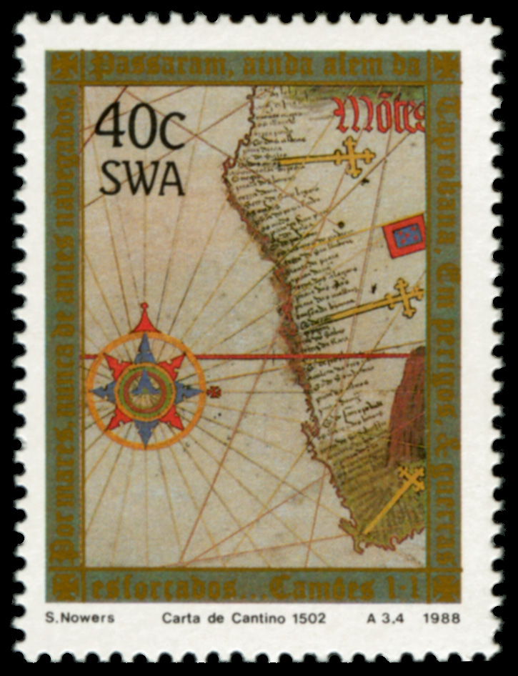
1988 7 January. 500th Anniversary of Cape of Good Hope. 40c 'Carta de Cantino 1502'.
The Portuguese mapped the coast of SWA and left stone crosses but did not venture into the Namib Desert.
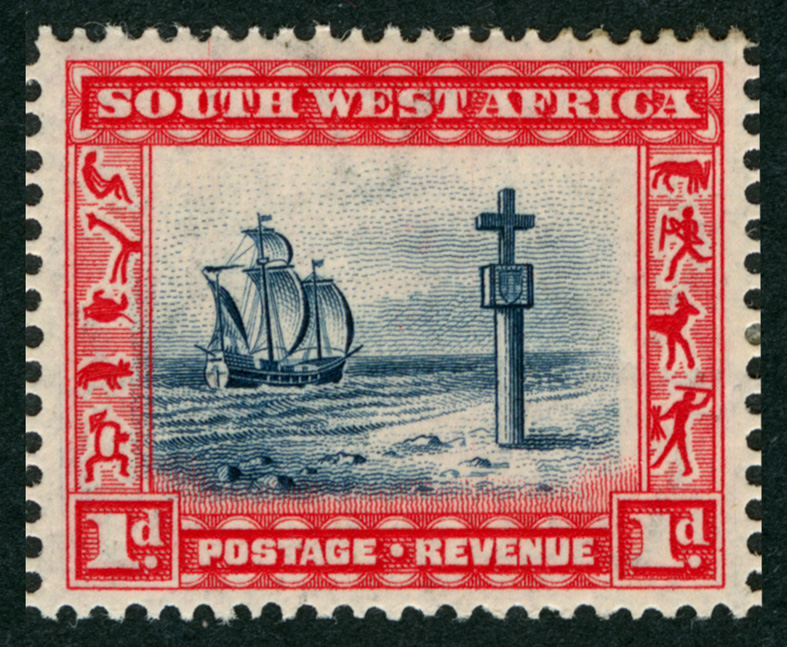
1931 5 March. 1st Pictorial Definitives of SWA. 1d 'Cape Cross'.
Mike has commented on this to the editor. He said "In the Walvis Bay story you showed Cape Cross, so I checked. The replica stands with hundreds of seals about 100 miles north of Swakopmund. The original from 1486 (11 ft) was the second voyage there of Captain Diogo Cao, ship Padria (Jesus). In 1893 a German Naval Commander took it to Germany. Under pressure it was returned to Namibia in 2019."
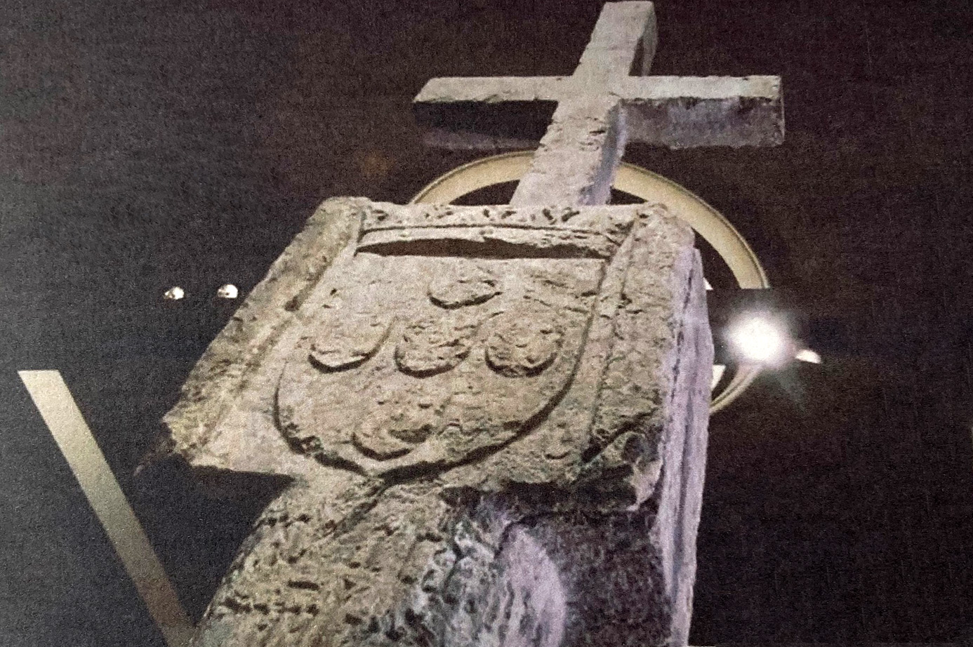
Pre-2019. Portuguese padrao from Cape Cross on display in German Museum.
Given its history, it is encouraging that Namibia wants this colonial relic returned to it.
1989 14 August. Namib Deser Sand Dunes. Full set of 4.
The Portuguese mapped the coast of SWA and left stone crosses but did not venture into the Namib Desert.
Circa 2000. Photo. Sand Dune at Susselsvlei. (Copyright, Mike Berry.)
Sand dunes half the size of this intimidated explorers from venturing inland from the sea.
Spot the people in this wonderful landscape.Walvis Bay is the only sheltered deep water port along the the entire length of Namibia's approximately 1572 km (977 miles) coastline. A feature of Namibia is that the Namib Desert stretches all the way along the Atlantic coastline, creating a formidable barrier between the sea and the interior. Indeed, this deterred European explorers from venturing inland. However, during the infamous Scramble for Africa by European powers in the 1880s, the Germans who had no African colonies took the opportunity to acquire SWA.
The British at the Cape had no plans to acquire SWA. Despite this, they did not welcome the Germans as colonial neighbours. Knowing that the Germans would need to import men and material in large quantities if they were to build a colony, the British decided make their endeavours as difficult as possible by depriving the German colony of the harbour at Walvis Bay. In 1878 the British annexed the land surrounding Walvis Bay, making it an exclave (not enclave) of the Cape Colony, some 654 km (392 miles) as the seagull flies south.
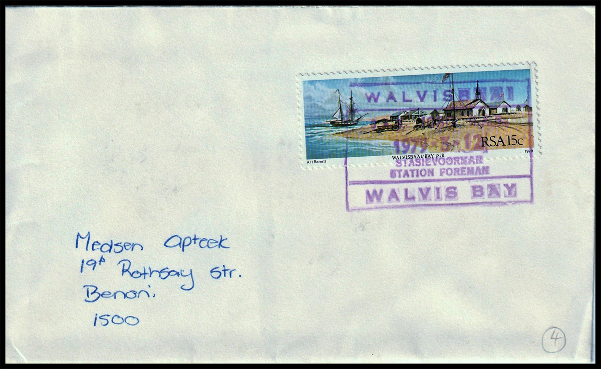
1979. Cover. WALVIS BAY (Bilingual) '1979 - 5 - 12' (SAR postmark - Station Foreman) to BENONI, SA.
The stamp is a South African one, Walvis Bay being a part of SA at the time.
1978 10 March. (Centenary) Annexation of Walvis Bay.
(Mike Berry Walvis Bay Collection).
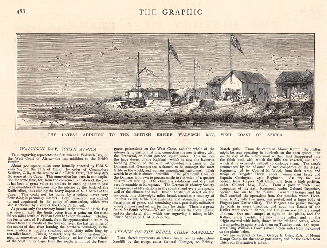
1878. Illustration ex The Graphic. May 18, 1878.
This sketch shows how small and primitive Walvis Bay was when annexed in 1878.
(Mike Berry Walvis Bay Collection)."Thank you, Mike" for sharing your display on the 'Postmarks of Walvis Bay' with us. This exclave of the Cape Colony created to frustrate German colonial ambition in SWA is arguably the most suitable place to start our travels studying the postal history of SWA!
For some time I have wanted to start a dedicated Topic on South West Africa (SWA), the territory that became modern-day Namibia. It is a fascinating collecting area for the philatelist and postal historian alike. First colonised by the Germans, SWA was occupied by the Union of SA during WW1. It received a limited mandate to rule SWA from the League of Nations in 1922. The Republic of SA relinquished control over SWA in 1989 following the first democratic elections that saw the new nation of Namibia emerge.
I was recently favoured by fortune to have a conversation with Mike Berry, a member of the South African Philately Club and the SA Collectors' Society (SACS). Mike mentioned his interest in SWA. He told me that he had a complete collection of all the postmarks of Walvis Bay as listed by Ralph Putzel in his ten volume 'The Postmarks of South Africa'. "Would you like to put it up?" he asked. I had no hesitation in saying, "yes, please!" Walvis Bay is the best and most obvious place to start any SWA postal history project. This was the spur I needed.
The pre-colonial history of SWA can be seen in the stamps and cover below. The Portuguese were the first to come sailing southwards. Bartholomew Dias landed at Walvis Bay (Golfo da Conceição) on 8th December 1487. He mapped the coast and erected padraos or stone crosses but did not venture into the desolate Namib Desert. For the next 300 years the vast territory of SWA was isolated from European influences, a refuge for the Cape's indigenous people fleeing the colonial rule of the Dutch and British. Over time Cape traders and German missionaries began to trickle in across the Orange River. The missionaries disapproved of British liberalism and agitated for German colonial control. When it loooked likely that SWA would become a German colony, the British annexed Walvis Bay to deny them SWA's only deep water port. This was the first consequential colonial act of territorial acquisition in SWA.
1988 7 January. 500th Anniversary of Cape of Good Hope. 40c 'Carta de Cantino 1502'.
The Portuguese mapped the coast of SWA and left stone crosses but did not venture into the Namib Desert.
1931 5 March. 1st Pictorial Definitives of SWA. 1d 'Cape Cross'.
Mike has commented on this to the editor. He said "In the Walvis Bay story you showed Cape Cross, so I checked. The replica stands with hundreds of seals about 100 miles north of Swakopmund. The original from 1486 (11 ft) was the second voyage there of Captain Diogo Cao, ship Padria (Jesus). In 1893 a German Naval Commander took it to Germany. Under pressure it was returned to Namibia in 2019."
Pre-2019. Portuguese padrao from Cape Cross on display in German Museum.
Given its history, it is encouraging that Namibia wants this colonial relic returned to it.

1989 14 August. Namib Deser Sand Dunes. Full set of 4.
The Portuguese mapped the coast of SWA and left stone crosses but did not venture into the Namib Desert.

Circa 2000. Photo. Sand Dune at Susselsvlei. (Copyright, Mike Berry.)
Sand dunes half the size of this intimidated explorers from venturing inland from the sea.
Spot the people in this wonderful landscape.
Walvis Bay is the only sheltered deep water port along the the entire length of Namibia's approximately 1572 km (977 miles) coastline. A feature of Namibia is that the Namib Desert stretches all the way along the Atlantic coastline, creating a formidable barrier between the sea and the interior. Indeed, this deterred European explorers from venturing inland. However, during the infamous Scramble for Africa by European powers in the 1880s, the Germans who had no African colonies took the opportunity to acquire SWA.
The British at the Cape had no plans to acquire SWA. Despite this, they did not welcome the Germans as colonial neighbours. Knowing that the Germans would need to import men and material in large quantities if they were to build a colony, the British decided make their endeavours as difficult as possible by depriving the German colony of the harbour at Walvis Bay. In 1878 the British annexed the land surrounding Walvis Bay, making it an exclave (not enclave) of the Cape Colony, some 654 km (392 miles) as the seagull flies south.
1979. Cover. WALVIS BAY (Bilingual) '1979 - 5 - 12' (SAR postmark - Station Foreman) to BENONI, SA.
The stamp is a South African one, Walvis Bay being a part of SA at the time.
1978 10 March. (Centenary) Annexation of Walvis Bay.
(Mike Berry Walvis Bay Collection).
1878. Illustration ex The Graphic. May 18, 1878.
This sketch shows how small and primitive Walvis Bay was when annexed in 1878.
(Mike Berry Walvis Bay Collection).
"Thank you, Mike" for sharing your display on the 'Postmarks of Walvis Bay' with us. This exclave of the Cape Colony created to frustrate German colonial ambition in SWA is arguably the most suitable place to start our travels studying the postal history of SWA!
Quote from Steve on July 22, 2025, 3:35 pmTHE POSTMARKS OF
WALVIS BAY
Brief History of Walvis Bay.Mike Berry.
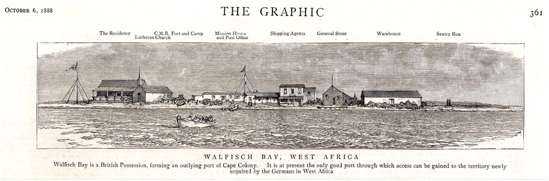
1888. Illustration ex The Graphic. October 6, 1888.
Ten years after annexation Walvis Bay beginning to show some growth.
(Mike Berry Walvis Bay Collection).According to archaeological findings the western coast of Southern Africa, in what is now known as Namibia, was home to small groups of Khoikhoi and the Aoni for thousands of years. It was discovered by the western world in 1487 when the Portugese navigator Bartholomeu Diaz anchored here when searching for a route to the east.
Three centuries later the next groups of westerners were active in the area. With the abundance of plankton in the cold Benguela current, the waters drew many whales, and from the 1780's European and North American whalers hunted in the bay, well into the early 1900’s. The Europeans had recognised the safe deep-water harbour’s strategic value in relation to the sea route around the Cape.
In January 1793 the Dutch flag was raised over the bay, but their rule was short lived. After occupation of the Cape the British quickly seized control over the area, more for administrative convenience, and safe passage of ships. Fearing the increased interest of the Germans in the country, Britain annexed the harbour, settlement area and several offshore islands (big guano deposits) on 12" March 1878. Six years later Walvis Bay was transferred to the Cape Colony and in 1910 incorporated into the Union of South Africa.
In the meantime, Germany had established sovereignty over what was then known as German South West Africa, and declared a dispute with Britain over the area boundaries. The dispute was settled in 1911, in British/South African favour based on the 1870 British sovereignty and the enclave of Walvis Bay was allocated an area of 1124 sq.km. When South African forces defeated the Germans in 1915 Walvis Bay was under martial law as part of South Africa. Following the 1919 Treaty of Versailles, the League of Nations assigned South Africa mandatory powers over South West Africa.
When Namibia became independent in 1990, the United Nations resolved that Walvis Bay should be incorporated into the new nation, and after external pressure this was eventually agreed with South Africa in 1994. By this time Walvis Bay had continued as an important fishing base, port, and good deposits of valuable Uranium were mined. The main mining ceased in 1997, at which date the Walvis Bay population was about 65,000.
Walvis Bay was known by the Dutch/Afrikaners as 'Walvisbaai', the Germans 'Walfischbai', some English as 'Walfish', 'Walwich' or even 'Woolwich Bay', all loosely based on the early value of whales.
The Earliest Postmark of Walvis Bay
Cape Post Office records show a Walvis Bay Postal Agency was opened in 1852, long before the 1884 incorporation of the area into the Cape. No identifiable mail of this period has yet been reported despite it being listed continuously until becoming a Post Office in 1881.
The earliest known postmark was the Barred Oval Numeral Canceller (BONC) 300 of the Cape. (Putzel. No. B 1.) The following is a very scarce and attractive BONC 300 proving card.
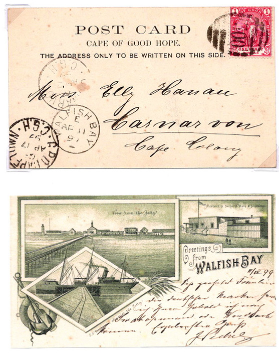
Greeting card in green bearing Cape of Good Hope 1d tied BONC 300 (Putzel type B 1) with Walfish Bay AP 11 99 code 'e' cds at left (Putzel type B 3a) strikes. Cape Town transit and Carnarvon arrival strikes.
(Mike Berry Walvis Bay Collection).Introduced in 1908, Putzel B 4 had two curved bars and a small Maltese Cross at base. It was destroyed in a Post Office fire on Monday 21st June 1909.
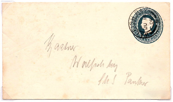
(Mike Berry Walvis Bay Collection)This and other similar covers addressed to various members of the SMS Panther crew, to be delivered to the vessel or collected from the Post Office, could be considered philatelic. SMS Panther was an Austro-Hungarian gunboat (light cruiser with ramming bow, built on the Clyde for the German Navy). It had taken part in the subsequently first named Gunboat Diplomacy incident against the French near Haiti.
1909. Light Cruiser SME Panther (K.u.K. Austro-Hungarian Navy).
The following item is from the occasion when the Walvis Bay Post Office burned down.
Putzel type 5, manuscript cancel Walfish Bay 28/6/09, used briefly after the Post OPffice was burned down, and the canceller destroyed*.
Letter card manuscript cancelled Walfish Bay, dated 29/6/09 addressed to a crew member of SMS Panther to be collected at the next port of call, Swakopmund. Backstamped receiving mark Swakopmund, Deutsch Sud-West Afrika6 30 6 09 4-5N.
(Mike Berry Walvis Bay Collection)*The State Archives report about the fire: "From records available here, the date was about June 24th 1909. The Post Office at that time was housed in one wing of the Residency. A temporary Post Office was then set up in the house of Dr Sinclair, who died unexpectedly a week after the fire". See next for a full description of the Walvis Bay Post Office fire.
THE POSTMARKS OF
WALVIS BAY
Brief History of Walvis Bay.
Mike Berry.
 1888. Illustration ex The Graphic. October 6, 1888.
Ten years after annexation Walvis Bay beginning to show some growth.
(Mike Berry Walvis Bay Collection).
According to archaeological findings the western coast of Southern Africa, in what is now known as Namibia, was home to small groups of Khoikhoi and the Aoni for thousands of years. It was discovered by the western world in 1487 when the Portugese navigator Bartholomeu Diaz anchored here when searching for a route to the east.
Three centuries later the next groups of westerners were active in the area. With the abundance of plankton in the cold Benguela current, the waters drew many whales, and from the 1780's European and North American whalers hunted in the bay, well into the early 1900’s. The Europeans had recognised the safe deep-water harbour’s strategic value in relation to the sea route around the Cape.
In January 1793 the Dutch flag was raised over the bay, but their rule was short lived. After occupation of the Cape the British quickly seized control over the area, more for administrative convenience, and safe passage of ships. Fearing the increased interest of the Germans in the country, Britain annexed the harbour, settlement area and several offshore islands (big guano deposits) on 12" March 1878. Six years later Walvis Bay was transferred to the Cape Colony and in 1910 incorporated into the Union of South Africa.
In the meantime, Germany had established sovereignty over what was then known as German South West Africa, and declared a dispute with Britain over the area boundaries. The dispute was settled in 1911, in British/South African favour based on the 1870 British sovereignty and the enclave of Walvis Bay was allocated an area of 1124 sq.km. When South African forces defeated the Germans in 1915 Walvis Bay was under martial law as part of South Africa. Following the 1919 Treaty of Versailles, the League of Nations assigned South Africa mandatory powers over South West Africa.
When Namibia became independent in 1990, the United Nations resolved that Walvis Bay should be incorporated into the new nation, and after external pressure this was eventually agreed with South Africa in 1994. By this time Walvis Bay had continued as an important fishing base, port, and good deposits of valuable Uranium were mined. The main mining ceased in 1997, at which date the Walvis Bay population was about 65,000.
Walvis Bay was known by the Dutch/Afrikaners as 'Walvisbaai', the Germans 'Walfischbai', some English as 'Walfish', 'Walwich' or even 'Woolwich Bay', all loosely based on the early value of whales.
The Earliest Postmark of Walvis Bay
Cape Post Office records show a Walvis Bay Postal Agency was opened in 1852, long before the 1884 incorporation of the area into the Cape. No identifiable mail of this period has yet been reported despite it being listed continuously until becoming a Post Office in 1881.
The earliest known postmark was the Barred Oval Numeral Canceller (BONC) 300 of the Cape. (Putzel. No. B 1.) The following is a very scarce and attractive BONC 300 proving card.
Greeting card in green bearing Cape of Good Hope 1d tied BONC 300 (Putzel type B 1) with Walfish Bay AP 11 99 code 'e' cds at left (Putzel type B 3a) strikes. Cape Town transit and Carnarvon arrival strikes.
(Mike Berry Walvis Bay Collection).
Introduced in 1908, Putzel B 4 had two curved bars and a small Maltese Cross at base. It was destroyed in a Post Office fire on Monday 21st June 1909.
 Dated JU 18 09 (Friday), three days before the Post Office, attached to the Residency, burned down and the canceller destroyed.
(Mike Berry Walvis Bay Collection)
This and other similar covers addressed to various members of the SMS Panther crew, to be delivered to the vessel or collected from the Post Office, could be considered philatelic. SMS Panther was an Austro-Hungarian gunboat (light cruiser with ramming bow, built on the Clyde for the German Navy). It had taken part in the subsequently first named Gunboat Diplomacy incident against the French near Haiti.
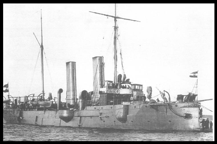
1909. Light Cruiser SME Panther (K.u.K. Austro-Hungarian Navy).
The following item is from the occasion when the Walvis Bay Post Office burned down.
Putzel type 5, manuscript cancel Walfish Bay 28/6/09, used briefly after the Post OPffice was burned down, and the canceller destroyed*.
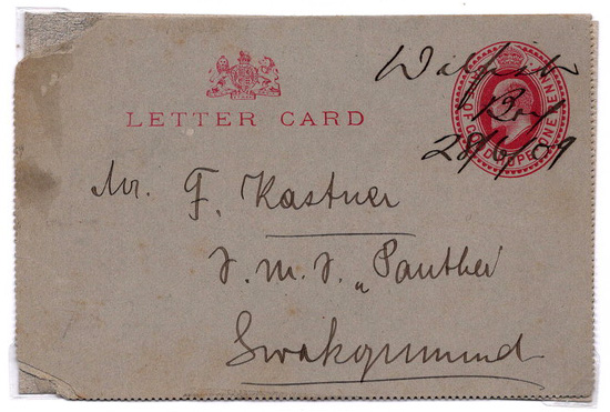
Letter card manuscript cancelled Walfish Bay, dated 29/6/09 addressed to a crew member of SMS Panther to be collected at the next port of call, Swakopmund. Backstamped receiving mark Swakopmund, Deutsch Sud-West Afrika6 30 6 09 4-5N.
(Mike Berry Walvis Bay Collection)
*The State Archives report about the fire: "From records available here, the date was about June 24th 1909. The Post Office at that time was housed in one wing of the Residency. A temporary Post Office was then set up in the house of Dr Sinclair, who died unexpectedly a week after the fire". See next for a full description of the Walvis Bay Post Office fire.
Quote from Steve on November 22, 2025, 4:30 pmThe 1909 Fire in Walfish Bay
In 1909 a fire on the night of 22/23 June, destroyed the Post Office and other offices at Walfish Bay, an exclave of the Cape Colony on the South West African coast. It is generally believed this fire destroyed the Walfish Bay Post Office's datestamp. This required all outgoing mail between 23rd June and 5th July to receive a manuscript cancellation. Covers or postal stationery from this time that are cancelled by hand in Walfish Bay are highly collectable. I have seen several such items. They are seldom accompanied by a full and accurate description of the fire. The issue of how and when the lost datestamp was replaced is muddled, to say the least.
A report on the fire was written by Mr J. M. Richards, the Walfish Bay Resident Magistrate and Civil Commissioner. In 1974 Mr Mervyn Emms, Director of the Post Office Museum in Pretoria. gave the SAP (The South African Philatelist, Vol. 50 No. 2 .February 1974) and Robson Lowe (The Philatelist, August 1975), permission to reprint the report. As this was over 50 years ago and because some explanations of the events surrounding the fire still remain ambiguous and uncertain or wrong I have copied Richard's original report from the SAP and include it below "for your edification and delight".
Richards was appointed Magistrate of Walfish Bay in 1909. In describing the fire in great detail he also casts some light on the nature or Walfish Bay's minimalist defences. It is not known who his report was submitted to. His immediate superior would have been the Governor of the Cape Colony, who in 1909 was Sir Walter Francis Hely‑Hutchinson, (Governor from 1901 to 1910). The Governor in turn reported to the British Colonial Office in London In his report to his superiors, Richards suggests that his report also be referred to the PMG (Post Master General) for his information. As this official report of the fire was made available to the SAP by Emms, the Director of the Post Office Museum in Pretoria, it apperas that whoever received his report forwarded a copy to the PMG.
In 1909 Walfish Bay (previously Walvisch Bay, later Walvis Bay) was administered by the Cape Colony, (later the Union of South Africa after 1910). In the Cape judicial administrative system, especially in small or remote districts, it was standard practice for one official to serve simultaneously as Resident Magistrate , Civil Commissioner, also Registrar of Deeds / District Officer, depending on the district’s needs In 1909 Walvis Bay was a small exclave with a minimal administrative structure. Contemporary Cape Government Gazettes and administrative lists show that its offices were combined under a single official, viz. Mr J. M. Richards who is listed in historical references as both Resident Magistrate and Civil Commissioner of Walfish Bay.
*****
Resident Magistrate's Office,
Walfish Bay,
25th June 1909.Sir,
DESTRUCTION OF PUBLIC OFFICES, WALFISH BAY, BY FIRE.
With reference to your cable of yesterday I have to submit my report on the burning of the Public Offices and Armoury. Unfortunately my typewriter has been destroyed, and I have to write this in a hurry to catch the post.
On the evening of June 22nd I retired to rest at about 10 p.m. not even thinking of fires, in view of the fact, of which I had been continually assured, that there had never been a fire at this Settlement.
At about 2 a.m. I imagine that I heard a loud knocking at my door. I was half awakened when this was renewed with vigour. I jumped out of bed, rushed to the record room which is part of my private residence, opened the outside door and to my horror saw the Public office in flames. The Acting Chief Constable, Mr. Blake, was outside calling out in a loud voice; the exact purport, of his words I cannot remember, except that he was calling for help, and drawing my attention to the fire. I rushed back and warned my wife and children to get out of the house immediately, and rushed out in my pyjamas and bare feet to render assistance. This all occupied a few moments. I then heard Mr. Blake call out "The Armoury" and realised in a moment that for the public safety, it was necessary above all things to secure the gunpowder and cartridges before the flames reached them.
I rushed to the Armoury, and there found the Acting Chief Constable, Police Constable McLaughlin and Mr. Stephens engaged in an (sic) heroic attempt at what I considered the serious risk of their lives, to effect this result. Mr. Blake was directing operations within, and with the help of his assistants was carrying arms and ammuni-tion. I also grabbed a few boxes of ammunition inside the door, and dragged them together with others they passed to me, towards the Police Quarters a few yards away. The flames were crackling in the adjoining room which was only separated by a thin wooden partition and which might have at any moment have found their way into this powder magazine and . . . the persons engaged in the rescue work into Eternity. The smoke was already pouring through the room. The following were saved, viz:—
Maxim Nordenfeldt gun and hoppers;*
14 Boxes of ammunition.
16 Lee Metford rifles.
19 Martini Henry rifles
21 Martini Henry rifles
11 Miscellaneous rifles.I was seriously considering the question of withdrawing the men from the Armoury, where cartridges started exploding and the men thereby received a warning to vacate the premises. Then followed more or less continous explosions of cartridges, which together with the roaring of the fire made a dreadful sound remembling (sic) a battle in miniature.
Explosion
In the midst of this turmoil, there was a terrific explosion which I subsequently found had hurled the roof of the premises across the residency against the fence of the Mission School. This must have been the 50 lbs. gun-powder. By this time most of the inhabitants had appeared on the scene and were all loyaly rendering every assistance. The continual firing of ammunition rendered it extremely dangerous for persons to go too near the fire itself, and, moreover, the latter was spreading so rapidly, that there was no time to save the contents of the offices. It seemed to me that the next important step was to try and save the Residency, and with this task in view to knock down that portion of the Public Offices actually joined by a door on to the Residency.
There was very little water to be had on the spot to extinguish the flames so it seemed advisable, with the little available to damp the corner of the Residency, which was already blistering from the extreme heat, as it would have been ridiculous to try and extinguish the flames with it. My bathroom and tank water (condensed) were therefore utilised, together with all water available. Runners were sent to the sea with buckets to secure further supplies. Mr. Gale sealed the roof of the Residency and applied water as far as possible to the men; P.C. McLaughlin, Hawes and myself applied water from the ground while Mr. Blake, the Rev. Schaible, Messrs. Stephens & Swanson battered down the end of my office adjoining my residence.
A gentle breeze was blowing from the South West, and the tongues of the flames were already almost lapping the wooden walls, which walls were within two yards of my office. However, at this critical juncture the wind suddenly dropped, and it then seemed for the first time probable that the building would be saved. When the work at the Armoury was stopped, it was too late to do much at the offices. Jagged and torn cartridge cases were flying in all directions, and in the morning it was seen that the ground was thickly strewn with them within 50 yards of the offices. Some had dented adjacent walls, and some had passed through the neighbouring window panes. I made an attempt assisted by Mr. Gale to save some of the books in my office, but I regret exceedingly to have to state, with very little success. When we entered the office the cartridges were exploding in the Armoury, the flames were very near, and dense smoke interfered with our efforts.
Had I attended to the office instead of to the Armoury, I certainly could have saved some of the more valuable books, but it seemed to me more necessary to see about the Armoury. Mr. Richards was assisted by many kind friends in the removal of my private effects, none of which were insured, from the Residency. The wind blowing at the time was the most dangerous for the latter building, which is a large one, and includes Light House and Public Library, so that although the Police Quarters and other buildings were in great danger also, the main efforts were first put forth to save the residency, and these efforts happily were successful.
Public offices
By this time the Armoury, Police Offices, Post Office and my office had been burned down and even while the cartridges were still occasionally exploding Europeans and Natives set to work with shovels of sand and buckets of water to kill the flames. A messenger was sent to Sand-fontein two miles away to call in Government boys to assist. I cannot pass by without mentioning the valuable assistance rendered by non-officials Messrs. Green, Tempel, Rev. Schaible, Oswell and son and their servants.
In my opinion it was hopeless from the outset to save the buildings without hose or fire engines. These rotten old buildings were more or less all built of wood and extremely inflammable. I am afraid if this residency caught fire it would be almost impossible to save it under existing circumstances, but of this more anon.
I annex reports of the Acting Chief Constable, Superintendent of Works and Jetty Superintendent of even date, which speak for themselves.
It is impossible to say what the origin of the fire was.
It looks very much as if Mr. Hawes, Jetty Superintendent, had been smoking a cigarette in the early part of the evening in the office in question, although he is uncertain of it. Yet, if that was the cause of the fire, one cannot understand why it should have taken all that time to develop. No one seems to have seen any signs of the fire before P.C. McLaughlin at 2 a.m., although the Police Office is surrounded by dwellings. Moreover, Mr. Gale stood outside the Chief Constable's office for some minutes about 9 p.m. and there was no sign of the fire then.
There had been a golf meeting in the Court Room at 8.15 p.m. — the Clerk's office and Post Office were between the Court Room and Police Office, having no communication by window or door. It appears that one of the gentlemen attending that meeting had a cigarette, although I had not noticed it. The Acting Chief Constable saw him throw it outside the Court Room into the yard shortly after he entered at the door, where everyone finally made their exit. The floor of the yard is covered with sand and it is an ordinary uncovered yard. It is quite out of the question to think for a moment that this could possibly have caused the fire, which all are agreed, originated in the Police Office. However, I thought it better to mention the fact.
Further, there was a tin of friction tubes for the signal gun in the Police Office, which had been there since Mr. Scott's tenure of office. This was labelled in print "not to be placed in magazine". I am not in a position to say whether this could not possibly have been the cause of the fire.
We have recently had the hottest weather I have ever experienced since my assumption of duty at this station. This rendered the atmosphere extremely dry and heated, and the wood was consequently in a more than usual inflammable (sic) condition. As a rule this is a cold damp foggy climate.
Books destroyed
Everything has been destroyed in the offices with the exception of the contents of the Post Office and my Safes. Births Register, Deaths Register, Marriage Register, Clearance Book for steamers, Report Book inwards for steamers, Index letters despatched, Letter books in use. My safe has been very much damaged, and it will be dangerous to use it in future, as it is warped, and the contents were found to have been badly scorched. In fact, I shall require new books to replace even those which were in the safe.
I really think that some means to fight fires should be provided at this isolated spot, where nearly all the buildings are of wood. I could easily have a volunteer brigade. I should think a few hundred yards of hose and a hand pump could be provided at a moderate cost, or perhaps a better arrangement. On the night of the fire the Superintendent of Public Works, Walfish Bay (Mr. Gale) found water (salt) within 18 inches of the surface, which was used on the fire.
I should like to add that the Chief Constable is Deputy Post Master, Walfish Bay, and that the Post Office with all contents was totally destroyed, with the exception of the contents of the safe. The safe itself was so much damaged that it was rendered absolutely useless. I would suggest that this report be referred to the Post Master General for his information.**
The Police Office, Post Office and my offices are now situate within the Residency.
From the annexed plan you will see what miserable little rooms formed the chain of buildings destroyed. The whole of them would about cover the space of my drawing room and dining room. The Residency appears on same plan for comparison.
I have no record now of the exact number of rounds of ammunition etc. destroyed but this is the quantity of arms and ammunition referred to in my letter to you, no. D3/? dated 15th May, 1909.
In conclusion I ought to mention the fact that the regulation as regards smoking in Public Offices has not been strictly observed.
Occasional smoking has been indulged in, but never at night to my knowledge.
Some of my private books and effects have been destroyed in the fire.
I regret to state all my official writing paper destroyed.
I have the honour to be,
Your obedient Servant,
(Sgnd.) . . . Richards
Resident Magistrate.* It is uncertain what weapon this refers to. It could be a standard size, small calibre infantry machine-gun or a reference to a 37 mm Nordenfelt-Maxim, the kind used during the South African war by the Boers against the British who knew it as the 'Pom-Pom'. It fired a one pound shell accurately over a distance of 3,000 yards. The barrel was water cooled with the shells fed from a 25 round fabric belt held in a magazine, the 'hopper'. Usually mounted on wheels, this was a heavy piece of light artillery.
** "I should like to add that the Chief Constable is Deputy Post Master, Walfish Bay". This suggests that at the time there was no Postmaster and that P.C. McLaughlin presumaby fulfilled this role. Is it his handwriting on the manuscript cancellers? "I would suggest that this report be referred to the Post Master General for his information." It would appear that this was done.
****
A Brief History of Walvisch / Walfish Bay Cancellers Possibly Relating to the Fire of 1909.I have used Ralph Putzel's 'The Postmarks of SA' which shows examples of the postmarks and F/V (Frescura / Visser) 'Revised Listing of the Post Offices and Postal Marking of the Cape of Good Hope 1792 -1910', (Second Post Publication Draft, 09.23) which does not show postmarks but which does show Earliest Recorded (ER) and Last Recorded (LR) dates of postmark use, which Putzel does not.
FV ER - LR: 27 SP 1889 - 04 MR 1899.Putzel 2]. Single Circle datestamp. (WALVISCH top, BAY at base).
FV ER - LR: 27 SP 1889 - 03 JY 1890Putzel 3]. Single Circle datestamp (WALFISH BAY 8 to 4 o'clock. Emblem at base.)
FV ER - LR: 13 DE 1893 - 28 FE 1906Putzel 4]. Double Circle datestamp (WALFISH BAY. -9 to 3+ o'clock. Cross and bars at base.)
FV ER - LR: 23 JY 1892 - 18 JY 1909 (New latest date of use!)We are told that the datestamp(s) was destroyed in the fire on 22/23 June 1909. Frescura and Visser state that the fire destroyed the Single Circle datestamp (No. 4) and BONC 300 (No. 1). They question if No. 2 was "brought back into use after 23 JU 1909?' ie. they suggest it was not destroyed. However, they show no dates for its use after 03 JY 1890.
Frescura and Visser say that "given the evidence ...." (What exactly?) "the obvious conclusion is that the local postmaster did have access to at least one office datestamp. Therefore, the use of a manuscript cancellation to process mails by the Resident Magistrate was either unwarranted, or of philatelic origin, or given the status of the public official involved, perhaps even bogus." This is unproven supposition. Putzel 1, 2 and 3 may all have been destoyed with Putzel 4 or returned to Head Office in 1906.
Putzel 5]. Manuscript Cancellation
FV ER - LR: 20 JU 1909 - 05 JY 1909MANUSCRIPT CANCELLATIONS
The fire was on the night of the 22/23 June.
The earliest maniscript cancellation is said to be '20 JU 1909'. As this predates the fire, it must be an error or a hoax!
We know manuscript cancels were used between 28 June 1909 and 5 July 1909.
We have no date for the arrival of a replacement datestamp.
FV show no new datestamp in use between 18 JU 1909 and before 06 MY 1914.FV suggest that there was a second Double Circle datestamp. Indeed, Putzel shows two, his No. 4 and No. 6.
Putzel 6]. Double Circle datestamp (WALFISH BAY. -9 to 3+ o'clock. Cross and bars at base)
FV ER - LR: 06 MY 14 - 10 SP 1914FV say this second Double Circle datestamp is "essentially similar in configuration" to No. 4 lost in the fire. There is nothing to show that No. 4 and No. 6 arrived together in Wafish Bay. Both Putzel and Frescura / Visser show no dates for No. 6 earlier than 1914 yet they suggest that "this could have been issued to Walfish Bay after 23 June 1909 to replace" the one lost in the fire. We should be wary of such speculation until we find proof that this or another datestamp was used after the fire and before 06 MY 1914, a huge gap in time.
This is a mystery that keeps on giving new twists and turns. Hopefully new discoveries will soon see it run out of road.
The 1909 Fire in Walfish Bay
In 1909 a fire on the night of 22/23 June, destroyed the Post Office and other offices at Walfish Bay, an exclave of the Cape Colony on the South West African coast. It is generally believed this fire destroyed the Walfish Bay Post Office's datestamp. This required all outgoing mail between 23rd June and 5th July to receive a manuscript cancellation. Covers or postal stationery from this time that are cancelled by hand in Walfish Bay are highly collectable. I have seen several such items. They are seldom accompanied by a full and accurate description of the fire. The issue of how and when the lost datestamp was replaced is muddled, to say the least.
A report on the fire was written by Mr J. M. Richards, the Walfish Bay Resident Magistrate and Civil Commissioner. In 1974 Mr Mervyn Emms, Director of the Post Office Museum in Pretoria. gave the SAP (The South African Philatelist, Vol. 50 No. 2 .February 1974) and Robson Lowe (The Philatelist, August 1975), permission to reprint the report. As this was over 50 years ago and because some explanations of the events surrounding the fire still remain ambiguous and uncertain or wrong I have copied Richard's original report from the SAP and include it below "for your edification and delight".
Richards was appointed Magistrate of Walfish Bay in 1909. In describing the fire in great detail he also casts some light on the nature or Walfish Bay's minimalist defences. It is not known who his report was submitted to. His immediate superior would have been the Governor of the Cape Colony, who in 1909 was Sir Walter Francis Hely‑Hutchinson, (Governor from 1901 to 1910). The Governor in turn reported to the British Colonial Office in London In his report to his superiors, Richards suggests that his report also be referred to the PMG (Post Master General) for his information. As this official report of the fire was made available to the SAP by Emms, the Director of the Post Office Museum in Pretoria, it apperas that whoever received his report forwarded a copy to the PMG.
In 1909 Walfish Bay (previously Walvisch Bay, later Walvis Bay) was administered by the Cape Colony, (later the Union of South Africa after 1910). In the Cape judicial administrative system, especially in small or remote districts, it was standard practice for one official to serve simultaneously as Resident Magistrate , Civil Commissioner, also Registrar of Deeds / District Officer, depending on the district’s needs In 1909 Walvis Bay was a small exclave with a minimal administrative structure. Contemporary Cape Government Gazettes and administrative lists show that its offices were combined under a single official, viz. Mr J. M. Richards who is listed in historical references as both Resident Magistrate and Civil Commissioner of Walfish Bay.
*****
Resident Magistrate's Office,
Walfish Bay,
25th June 1909.
Sir,
DESTRUCTION OF PUBLIC OFFICES, WALFISH BAY, BY FIRE.
With reference to your cable of yesterday I have to submit my report on the burning of the Public Offices and Armoury. Unfortunately my typewriter has been destroyed, and I have to write this in a hurry to catch the post.
On the evening of June 22nd I retired to rest at about 10 p.m. not even thinking of fires, in view of the fact, of which I had been continually assured, that there had never been a fire at this Settlement.
At about 2 a.m. I imagine that I heard a loud knocking at my door. I was half awakened when this was renewed with vigour. I jumped out of bed, rushed to the record room which is part of my private residence, opened the outside door and to my horror saw the Public office in flames. The Acting Chief Constable, Mr. Blake, was outside calling out in a loud voice; the exact purport, of his words I cannot remember, except that he was calling for help, and drawing my attention to the fire. I rushed back and warned my wife and children to get out of the house immediately, and rushed out in my pyjamas and bare feet to render assistance. This all occupied a few moments. I then heard Mr. Blake call out "The Armoury" and realised in a moment that for the public safety, it was necessary above all things to secure the gunpowder and cartridges before the flames reached them.
I rushed to the Armoury, and there found the Acting Chief Constable, Police Constable McLaughlin and Mr. Stephens engaged in an (sic) heroic attempt at what I considered the serious risk of their lives, to effect this result. Mr. Blake was directing operations within, and with the help of his assistants was carrying arms and ammuni-tion. I also grabbed a few boxes of ammunition inside the door, and dragged them together with others they passed to me, towards the Police Quarters a few yards away. The flames were crackling in the adjoining room which was only separated by a thin wooden partition and which might have at any moment have found their way into this powder magazine and . . . the persons engaged in the rescue work into Eternity. The smoke was already pouring through the room. The following were saved, viz:—
Maxim Nordenfeldt gun and hoppers;*
14 Boxes of ammunition.
16 Lee Metford rifles.
19 Martini Henry rifles
21 Martini Henry rifles
11 Miscellaneous rifles.
I was seriously considering the question of withdrawing the men from the Armoury, where cartridges started exploding and the men thereby received a warning to vacate the premises. Then followed more or less continous explosions of cartridges, which together with the roaring of the fire made a dreadful sound remembling (sic) a battle in miniature.
Explosion
In the midst of this turmoil, there was a terrific explosion which I subsequently found had hurled the roof of the premises across the residency against the fence of the Mission School. This must have been the 50 lbs. gun-powder. By this time most of the inhabitants had appeared on the scene and were all loyaly rendering every assistance. The continual firing of ammunition rendered it extremely dangerous for persons to go too near the fire itself, and, moreover, the latter was spreading so rapidly, that there was no time to save the contents of the offices. It seemed to me that the next important step was to try and save the Residency, and with this task in view to knock down that portion of the Public Offices actually joined by a door on to the Residency.
There was very little water to be had on the spot to extinguish the flames so it seemed advisable, with the little available to damp the corner of the Residency, which was already blistering from the extreme heat, as it would have been ridiculous to try and extinguish the flames with it. My bathroom and tank water (condensed) were therefore utilised, together with all water available. Runners were sent to the sea with buckets to secure further supplies. Mr. Gale sealed the roof of the Residency and applied water as far as possible to the men; P.C. McLaughlin, Hawes and myself applied water from the ground while Mr. Blake, the Rev. Schaible, Messrs. Stephens & Swanson battered down the end of my office adjoining my residence.
A gentle breeze was blowing from the South West, and the tongues of the flames were already almost lapping the wooden walls, which walls were within two yards of my office. However, at this critical juncture the wind suddenly dropped, and it then seemed for the first time probable that the building would be saved. When the work at the Armoury was stopped, it was too late to do much at the offices. Jagged and torn cartridge cases were flying in all directions, and in the morning it was seen that the ground was thickly strewn with them within 50 yards of the offices. Some had dented adjacent walls, and some had passed through the neighbouring window panes. I made an attempt assisted by Mr. Gale to save some of the books in my office, but I regret exceedingly to have to state, with very little success. When we entered the office the cartridges were exploding in the Armoury, the flames were very near, and dense smoke interfered with our efforts.
Had I attended to the office instead of to the Armoury, I certainly could have saved some of the more valuable books, but it seemed to me more necessary to see about the Armoury. Mr. Richards was assisted by many kind friends in the removal of my private effects, none of which were insured, from the Residency. The wind blowing at the time was the most dangerous for the latter building, which is a large one, and includes Light House and Public Library, so that although the Police Quarters and other buildings were in great danger also, the main efforts were first put forth to save the residency, and these efforts happily were successful.
Public offices
By this time the Armoury, Police Offices, Post Office and my office had been burned down and even while the cartridges were still occasionally exploding Europeans and Natives set to work with shovels of sand and buckets of water to kill the flames. A messenger was sent to Sand-fontein two miles away to call in Government boys to assist. I cannot pass by without mentioning the valuable assistance rendered by non-officials Messrs. Green, Tempel, Rev. Schaible, Oswell and son and their servants.
In my opinion it was hopeless from the outset to save the buildings without hose or fire engines. These rotten old buildings were more or less all built of wood and extremely inflammable. I am afraid if this residency caught fire it would be almost impossible to save it under existing circumstances, but of this more anon.
I annex reports of the Acting Chief Constable, Superintendent of Works and Jetty Superintendent of even date, which speak for themselves.
It is impossible to say what the origin of the fire was.
It looks very much as if Mr. Hawes, Jetty Superintendent, had been smoking a cigarette in the early part of the evening in the office in question, although he is uncertain of it. Yet, if that was the cause of the fire, one cannot understand why it should have taken all that time to develop. No one seems to have seen any signs of the fire before P.C. McLaughlin at 2 a.m., although the Police Office is surrounded by dwellings. Moreover, Mr. Gale stood outside the Chief Constable's office for some minutes about 9 p.m. and there was no sign of the fire then.
There had been a golf meeting in the Court Room at 8.15 p.m. — the Clerk's office and Post Office were between the Court Room and Police Office, having no communication by window or door. It appears that one of the gentlemen attending that meeting had a cigarette, although I had not noticed it. The Acting Chief Constable saw him throw it outside the Court Room into the yard shortly after he entered at the door, where everyone finally made their exit. The floor of the yard is covered with sand and it is an ordinary uncovered yard. It is quite out of the question to think for a moment that this could possibly have caused the fire, which all are agreed, originated in the Police Office. However, I thought it better to mention the fact.
Further, there was a tin of friction tubes for the signal gun in the Police Office, which had been there since Mr. Scott's tenure of office. This was labelled in print "not to be placed in magazine". I am not in a position to say whether this could not possibly have been the cause of the fire.
We have recently had the hottest weather I have ever experienced since my assumption of duty at this station. This rendered the atmosphere extremely dry and heated, and the wood was consequently in a more than usual inflammable (sic) condition. As a rule this is a cold damp foggy climate.
Books destroyed
Everything has been destroyed in the offices with the exception of the contents of the Post Office and my Safes. Births Register, Deaths Register, Marriage Register, Clearance Book for steamers, Report Book inwards for steamers, Index letters despatched, Letter books in use. My safe has been very much damaged, and it will be dangerous to use it in future, as it is warped, and the contents were found to have been badly scorched. In fact, I shall require new books to replace even those which were in the safe.
I really think that some means to fight fires should be provided at this isolated spot, where nearly all the buildings are of wood. I could easily have a volunteer brigade. I should think a few hundred yards of hose and a hand pump could be provided at a moderate cost, or perhaps a better arrangement. On the night of the fire the Superintendent of Public Works, Walfish Bay (Mr. Gale) found water (salt) within 18 inches of the surface, which was used on the fire.
I should like to add that the Chief Constable is Deputy Post Master, Walfish Bay, and that the Post Office with all contents was totally destroyed, with the exception of the contents of the safe. The safe itself was so much damaged that it was rendered absolutely useless. I would suggest that this report be referred to the Post Master General for his information.**
The Police Office, Post Office and my offices are now situate within the Residency.
From the annexed plan you will see what miserable little rooms formed the chain of buildings destroyed. The whole of them would about cover the space of my drawing room and dining room. The Residency appears on same plan for comparison.
I have no record now of the exact number of rounds of ammunition etc. destroyed but this is the quantity of arms and ammunition referred to in my letter to you, no. D3/? dated 15th May, 1909.
In conclusion I ought to mention the fact that the regulation as regards smoking in Public Offices has not been strictly observed.
Occasional smoking has been indulged in, but never at night to my knowledge.
Some of my private books and effects have been destroyed in the fire.
I regret to state all my official writing paper destroyed.
I have the honour to be,
Your obedient Servant,
(Sgnd.) . . . Richards
Resident Magistrate.
* It is uncertain what weapon this refers to. It could be a standard size, small calibre infantry machine-gun or a reference to a 37 mm Nordenfelt-Maxim, the kind used during the South African war by the Boers against the British who knew it as the 'Pom-Pom'. It fired a one pound shell accurately over a distance of 3,000 yards. The barrel was water cooled with the shells fed from a 25 round fabric belt held in a magazine, the 'hopper'. Usually mounted on wheels, this was a heavy piece of light artillery.
** "I should like to add that the Chief Constable is Deputy Post Master, Walfish Bay". This suggests that at the time there was no Postmaster and that P.C. McLaughlin presumaby fulfilled this role. Is it his handwriting on the manuscript cancellers? "I would suggest that this report be referred to the Post Master General for his information." It would appear that this was done.
****
A Brief History of Walvisch / Walfish Bay Cancellers Possibly Relating to the Fire of 1909.
I have used Ralph Putzel's 'The Postmarks of SA' which shows examples of the postmarks and F/V (Frescura / Visser) 'Revised Listing of the Post Offices and Postal Marking of the Cape of Good Hope 1792 -1910', (Second Post Publication Draft, 09.23) which does not show postmarks but which does show Earliest Recorded (ER) and Last Recorded (LR) dates of postmark use, which Putzel does not.
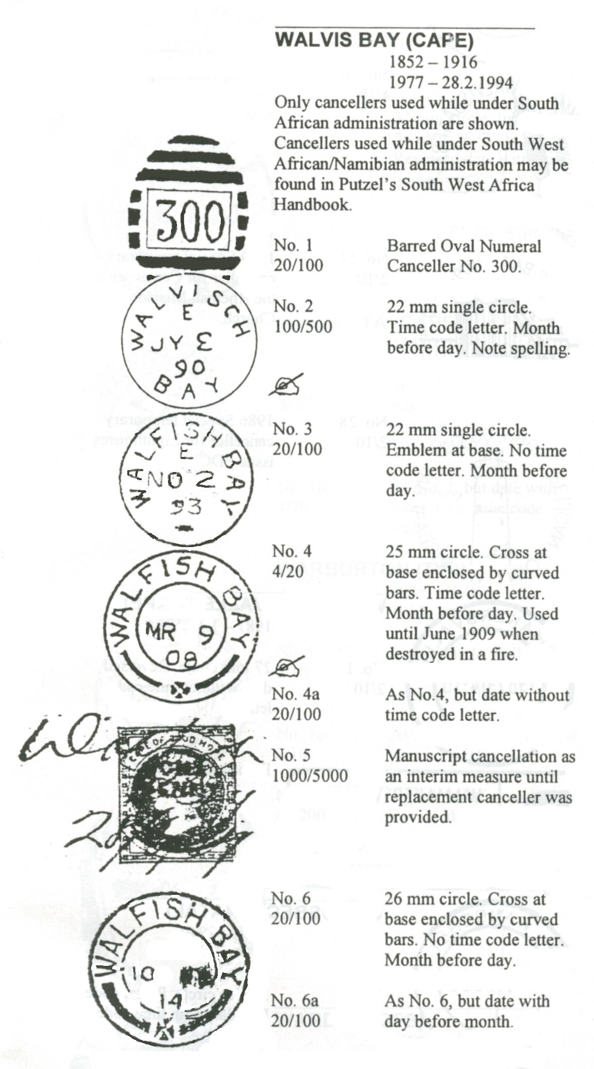 Putzel 1]. BONC (Barred Oval Numeral Canceller) 300 as Walvisch Bay's first postmark,
FV ER - LR: 27 SP 1889 - 04 MR 1899.
Putzel 2]. Single Circle datestamp. (WALVISCH top, BAY at base).
FV ER - LR: 27 SP 1889 - 03 JY 1890
Putzel 3]. Single Circle datestamp (WALFISH BAY 8 to 4 o'clock. Emblem at base.)
FV ER - LR: 13 DE 1893 - 28 FE 1906
Putzel 4]. Double Circle datestamp (WALFISH BAY. -9 to 3+ o'clock. Cross and bars at base.)
FV ER - LR: 23 JY 1892 - 18 JY 1909 (New latest date of use!)
We are told that the datestamp(s) was destroyed in the fire on 22/23 June 1909. Frescura and Visser state that the fire destroyed the Single Circle datestamp (No. 4) and BONC 300 (No. 1). They question if No. 2 was "brought back into use after 23 JU 1909?' ie. they suggest it was not destroyed. However, they show no dates for its use after 03 JY 1890.
Frescura and Visser say that "given the evidence ...." (What exactly?) "the obvious conclusion is that the local postmaster did have access to at least one office datestamp. Therefore, the use of a manuscript cancellation to process mails by the Resident Magistrate was either unwarranted, or of philatelic origin, or given the status of the public official involved, perhaps even bogus." This is unproven supposition. Putzel 1, 2 and 3 may all have been destoyed with Putzel 4 or returned to Head Office in 1906.
Putzel 5]. Manuscript Cancellation
FV ER - LR: 20 JU 1909 - 05 JY 1909
MANUSCRIPT CANCELLATIONS
The fire was on the night of the 22/23 June.
The earliest maniscript cancellation is said to be '20 JU 1909'. As this predates the fire, it must be an error or a hoax!
We know manuscript cancels were used between 28 June 1909 and 5 July 1909.
We have no date for the arrival of a replacement datestamp.
FV show no new datestamp in use between 18 JU 1909 and before 06 MY 1914.
FV suggest that there was a second Double Circle datestamp. Indeed, Putzel shows two, his No. 4 and No. 6.
Putzel 6]. Double Circle datestamp (WALFISH BAY. -9 to 3+ o'clock. Cross and bars at base)
FV ER - LR: 06 MY 14 - 10 SP 1914
FV say this second Double Circle datestamp is "essentially similar in configuration" to No. 4 lost in the fire. There is nothing to show that No. 4 and No. 6 arrived together in Wafish Bay. Both Putzel and Frescura / Visser show no dates for No. 6 earlier than 1914 yet they suggest that "this could have been issued to Walfish Bay after 23 June 1909 to replace" the one lost in the fire. We should be wary of such speculation until we find proof that this or another datestamp was used after the fire and before 06 MY 1914, a huge gap in time.
This is a mystery that keeps on giving new twists and turns. Hopefully new discoveries will soon see it run out of road.
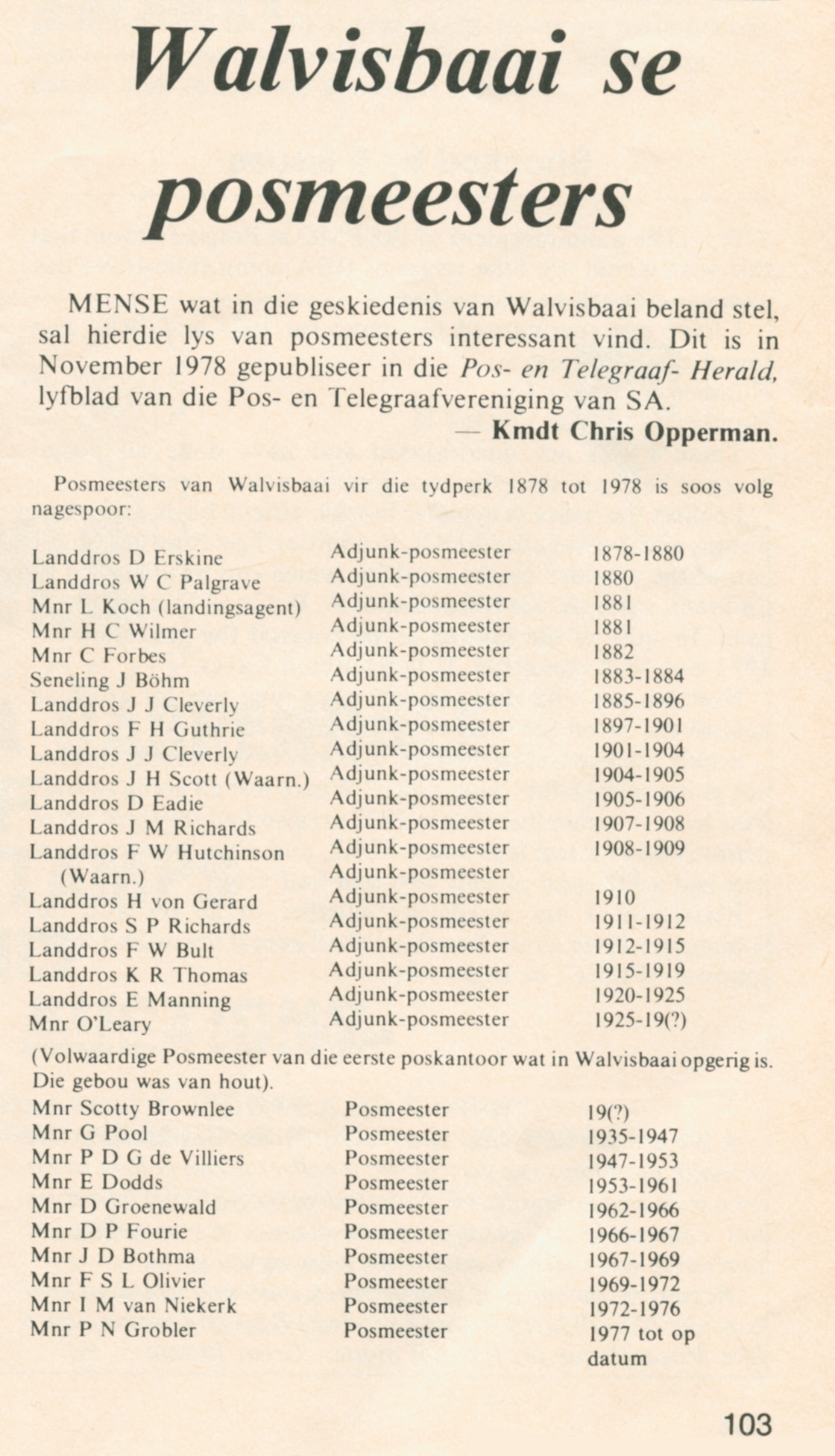
Quote from Steve on November 24, 2025, 5:57 pmPostmasters of Walvis Bay 1878 - 1978
I saw this in a back copy of the South African Philatelist (April 1979, page 103). It was submitted in Afrikaans by Commandant Chris Opperman. I have not translated it as the information shown in the image below is self-evident, I think
A few pointers. 'Adjunk' is Afrikaans for 'Deputy'. What is clear from this if it is correct is that Walvis Bay had no Postmaster but used a Deputy Postmaster to fulfill the function up until some time betwee 1925 - 1935 when the first Postmaster, Mr Scotty Brownlee, was appointed. Further, with the exception of 1881 - 1884 period, the RM (Resident Magistrate) was the Deputy Postmaster until 1925.
Those who have read Resident Magistrate J M Richards' account of the fire will know that he was ably assisted by the "Chief Constable" who "is Deputy Post Master, Walfish Bay". Richards report refers to Chief Constable McLaughlin as the Deputy Post Master, not himself. Perhaps it was the duty of the magistrate to deputise a postal assistant? Who better than a constable who had little to do? If this is correct and was standard practice, then whoever was handling Walvis Bay's mail was someone NOT shown on the list below!
I do not know what a 'seneling' is. (J H Böhm 1883 - 1884.) It is likely a typo. In Afrikaans a 'sendeling' is a missionary. One of the most influential German missionaries in SWA was Johann Friedrich Albrecht Böhm of the Rhenish Mission Society who arrived in South West Africa in 1863 to establish missionary stations. In his later years Böhm lived in Walvis Bay between 1881 - 1907.
Finally, I stated in the article above that Richards was appointed RM in 1909. Kmdt Oppermans' advice below is taken from the Post and Telegraph Herald, (November 1978, Post and Telegraph Society). As reprinted in the SAP it states that Richards was appointed in 1907 - 1908. This does not place Richards in Walvis Bay at the time of the fire. Something is wrong somewhere. I think it is true to say that Richards was in Walfish Bay at the time of the fire in 1909! It also looks like RMs served a year in Walvis Bay.
Postmasters of Walvis Bay 1878 - 1978
I saw this in a back copy of the South African Philatelist (April 1979, page 103). It was submitted in Afrikaans by Commandant Chris Opperman. I have not translated it as the information shown in the image below is self-evident, I think
A few pointers. 'Adjunk' is Afrikaans for 'Deputy'. What is clear from this if it is correct is that Walvis Bay had no Postmaster but used a Deputy Postmaster to fulfill the function up until some time betwee 1925 - 1935 when the first Postmaster, Mr Scotty Brownlee, was appointed. Further, with the exception of 1881 - 1884 period, the RM (Resident Magistrate) was the Deputy Postmaster until 1925.
Those who have read Resident Magistrate J M Richards' account of the fire will know that he was ably assisted by the "Chief Constable" who "is Deputy Post Master, Walfish Bay". Richards report refers to Chief Constable McLaughlin as the Deputy Post Master, not himself. Perhaps it was the duty of the magistrate to deputise a postal assistant? Who better than a constable who had little to do? If this is correct and was standard practice, then whoever was handling Walvis Bay's mail was someone NOT shown on the list below!
I do not know what a 'seneling' is. (J H Böhm 1883 - 1884.) It is likely a typo. In Afrikaans a 'sendeling' is a missionary. One of the most influential German missionaries in SWA was Johann Friedrich Albrecht Böhm of the Rhenish Mission Society who arrived in South West Africa in 1863 to establish missionary stations. In his later years Böhm lived in Walvis Bay between 1881 - 1907.
Finally, I stated in the article above that Richards was appointed RM in 1909. Kmdt Oppermans' advice below is taken from the Post and Telegraph Herald, (November 1978, Post and Telegraph Society). As reprinted in the SAP it states that Richards was appointed in 1907 - 1908. This does not place Richards in Walvis Bay at the time of the fire. Something is wrong somewhere. I think it is true to say that Richards was in Walfish Bay at the time of the fire in 1909! It also looks like RMs served a year in Walvis Bay.
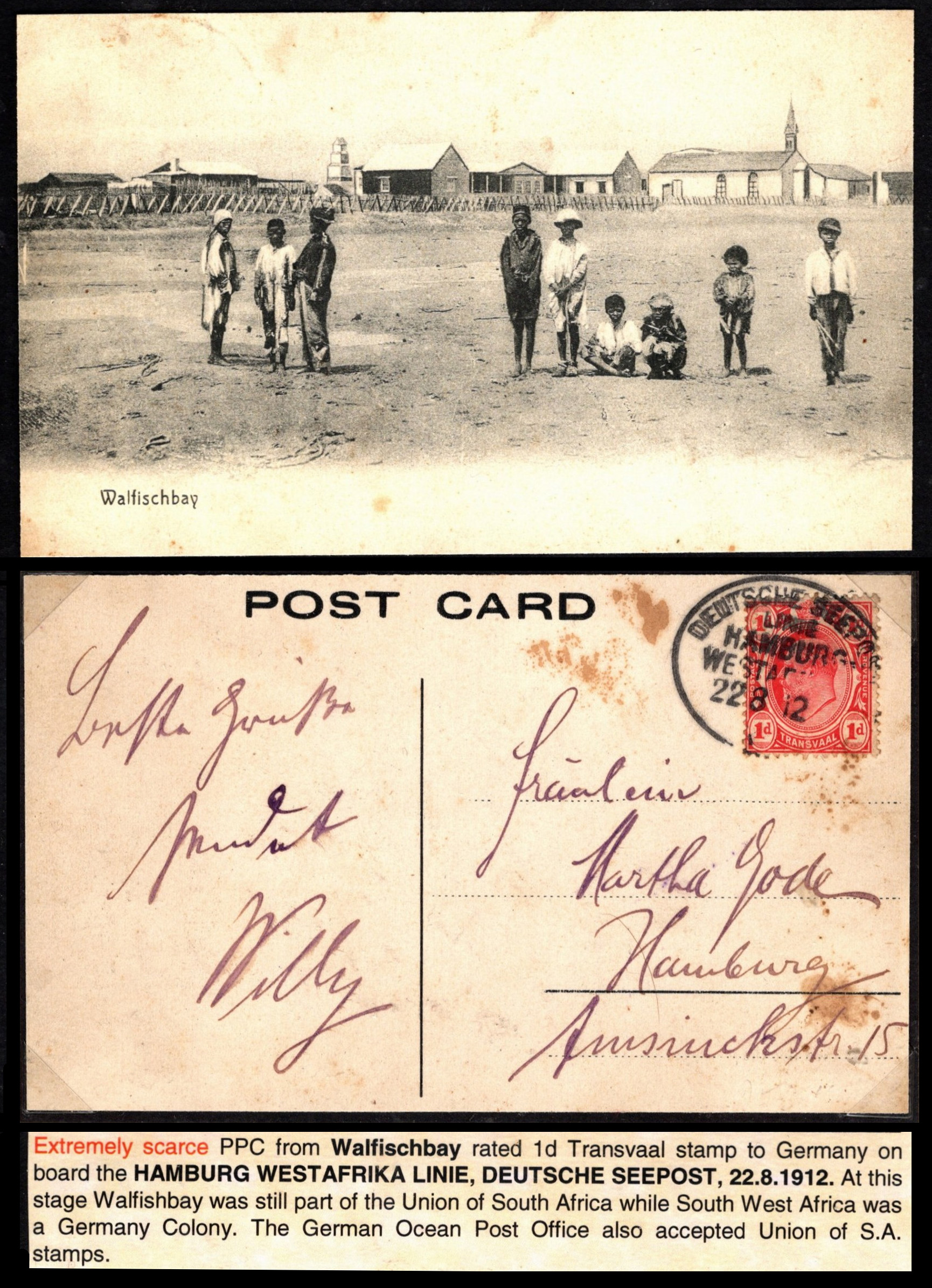
Quote from Steve on December 16, 2025, 10:13 amThe following postcard comes from a recent Kenny Napier Auction. What is notable about it is that this is an uncommon, indeed scarce, maybe rare, postcard that has a view different to most other PCs, in this case one looking south-east. Is that a lighthousae centre left?
This postcard could be used in any Walvis Bay display, including a PAQUEBOT one, not to mention a study of colonial urban urchins of the great and grand late Edwardian Age when "to be an Engishman is to win first prize in God's Lottery of Life". (Cecil J. Rhodes. Imperialist.)
What is the purpose of this postcard. I imagine that it is to show a view of Walvis Bay as a backwater of Empire. To me, however, it seems to show a barren, bleak and socially hopeless place to exist in. It is not a pretty picture.
In this postcard these kids serve as a coat-hangers for virtue-signalling do-gooders. Just as in enlightened Victorian London where its streetlights stretched only as far as the shadows where poverty began and the poor lived in miserable darkness just down the road from the rich, these neglected children growing up in this distant outpost of empire are Britain's discarded colonial cousins. The British Empire was a long-established system of inequality based on the distinction between genteel wealth and title and the vulgarity of working class poverty and labour. It existed within a class sytem that had English superioirity as its uncommon denominator.
The following postcard comes from a recent Kenny Napier Auction. What is notable about it is that this is an uncommon, indeed scarce, maybe rare, postcard that has a view different to most other PCs, in this case one looking south-east. Is that a lighthousae centre left?
This postcard could be used in any Walvis Bay display, including a PAQUEBOT one, not to mention a study of colonial urban urchins of the great and grand late Edwardian Age when "to be an Engishman is to win first prize in God's Lottery of Life". (Cecil J. Rhodes. Imperialist.)
What is the purpose of this postcard. I imagine that it is to show a view of Walvis Bay as a backwater of Empire. To me, however, it seems to show a barren, bleak and socially hopeless place to exist in. It is not a pretty picture.
In this postcard these kids serve as a coat-hangers for virtue-signalling do-gooders. Just as in enlightened Victorian London where its streetlights stretched only as far as the shadows where poverty began and the poor lived in miserable darkness just down the road from the rich, these neglected children growing up in this distant outpost of empire are Britain's discarded colonial cousins. The British Empire was a long-established system of inequality based on the distinction between genteel wealth and title and the vulgarity of working class poverty and labour. It existed within a class sytem that had English superioirity as its uncommon denominator.