Table Mountain, the Inspiration
Quote from Steve on January 2, 2023, 6:26 pmView Gawie Hugo's 'Table Mountain, the Inspiration' here.
Many a time during my darkest days in Cape Town I sought refuge in walking around the lower foothills and contour paths of Table Mountain. Once, I rounded a bend in a track where water the colour of brandy sparkled sweetly over stones cool from the shade of wild almonds, yellowwoods and Cape olives. There, sitting on a stone dam wall like dryads or naiads in a Mucha art nouveau print, stunningly dappled by shadow and sunlight, were three of the most beautiful 'Coloured' girls, one with a magnificent 'afro', refugees like me from the Mother City's one-sided love. The enchantment of that scene took my breath away. Was it the same for the lonely sons of the first settlers?
Page 1: Table Mountain, the Inspiration
A loose translation of the Dutch in the 'Inscription on the painting' is "In the year 1772 in the month of May, I, Jakob van Renen of the Cape, departed to the fatherland with the ship named Borselen, commanded by Captain Sierevelt and at the same time made this sketch of the ..... above the plate of the bay .... from a ship at the time on the plate ..... Tjiena". The term 'Plaad' or 'plate' seems odd. However, there is a stretch of coastline that runs from Hermanus to Die Kelders just outside Gansbaai that is called 'Die Plaat' (Afr. the sheet). This refers to the long coastal plain that drops considerably just offshore. Sorry, that's the best I can offer.
Page 4. Landing of Jan Anthonisz van Riebeeck 1652.
The pair of stamps shown is the 1952 2d Tercentenary 'Landing of van Riebeeck' as used on the Home page (Ist January 2023). The red arrow on this stamp points to the 'Moon over Table Bay' variety. The 1/- shown alongside is described "Signalhill as the backdrop". This is wrong. It is Devil's Peak in the distance. I speak from experience. I was conceived in the shadow of Devil's Peak in my grandmother's house in Rosebank, its closest suburb. I would recognise it anywhere. Our house in Camp Road, Pinelands, had an unfettered view of Devil's Peak from the living room window. I was so in thrall of Cape Town's mountains that I named my first business Signal Hill Publications (Pty) Ltd., (see part cover below), a use of my initials and a cheeky part rip-off of McGraw Hill. It worked. Some took me seriously!
Page 5: The First Fort
Jan van Riebeeck, the Dutch Commander at the Cape, had been ordered by the VOC (Dutch East India Company) to build a garden, a hospital and a fort in Table Bay beneath the mountain. On page 5, Gawie shows a superb example of this first sod and timber fort (1652 - 1666 when work on the Castle began). The fort was intended to protect Dutch commercial interests from rival foreign powers, as well as the VOC's servants, but once built it became a means of protecting and distancing the Dutch from the indigenous people, the Khoi, as well as the Peninsula's many predators, most especially the magnificent black-maned Table Mountain lion.
Jan, Krotoa, Eva and Oom Paul President Kruger
Jan van Riebeeck initially attempted to build cordial relations with the Khoi with whom the VOC hoped to trade as well as employ. To facilitate communication with the Khoi, he bought into the fort a young Khoi woman, Krotoa, whom he gave the Christian name of 'Eva'. (See page 47). A translator and niece of 'Harry the Hottentot', she married Pieter van Meerhof in 1664, the first Khoi to marry a European and also the first according to Christian customs. The Peltzers, Krugers, Steenkamps and other Afrikaner families are included among her descendants today. The subsequent use of Eva as a racist warning against miscegenation has deliberately ignored van Riebeeck's encouragement of this marriage.
Among a number of other factors, segregation as it has historically been practised by White South Africans probably evolved in the first instance from van Riebeeck excluding the Khoi from the first fort on the basis of growing mistrust once the Khoi withdrew their support and began a campaign of harrassment. A hedge of bitter almonds extended this segregation to the rich and contested farmland along the Liesbeeck River which the Dutch had unilaterally claimed as theirs. As a boy my pals and I would ride our bicycles from Pinelands along the newly built Settlers' Way to the stretch of the Liesbeeck River between Mowbray and the Observatory. At Mowbray there was a run-down farmhouse on the far bank alongside the river where a baboon was kept on a chain It was more frightening than any dog.
Page 8. English Rule.
Gawie's sub-heading has an interesting back-story. The British Empire was driven by English Imperialism against its Celtic neighbours. First the Cornish Britons, then the Welsh fell, followed by the Irish. Finally the Scots begged a Union once their own failed imperial ambition caused national impoverishment. In 1806 when the Batavian Republic's Dutch colony at the Cape was occupied it was by Great Britain, not the English. This is an easy error to make, one I make quite often as a South African and strive to correct.
In South Africa, British rule was interpreted by Boers, today's Afrikaners, as 'English rule'. One of the main reasons for this is that at times English was the only official language, as it presumably was in Wales, Ireland and Scotland at the time. Unlike other colonies, South Africa experienced only limited influence from English-speaking Scottish administrators and educators. However, Scottish clergymen who learned to speak Dutch - and thereby became 'Afrikaners' - had great acceptance in South Africa. Despite get-rich-quick gold South Africa was never a popular immigration destination for the British working class who chose to immigrate to the USA, Canada, Australia and New Zealand. Thus for all of the 19th and for part of the 20th c., English was the language shoved in the faces of Boers, often by English colonial officials. Just as the Welsh, and Scots are quick to resent South Africans calling the UK 'England' today, most are quicker to denounce their shared colonial complicity as the exclusive fault of the English. This is a symptom of a once great country and empire falling apart at the seams.
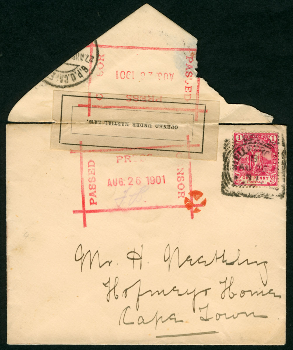
Page 15. Anglo-Boer War Cover
I have two of these Stellenbosch covers showing the small orange cork canceller, neither of which are going to the OFS - one to Cape Town, the other to Pretoria. That being the case, I disagree with the statement that the small orange cork canceller was used by the Printing Works Censor, Bloemfontein. They were clearly used in a place common to all the covers - Stellenbosch.
As my two Stellenbosch covers have always fascinated me, I am pleased to see another one here. All three are from the South African War era of mid to late 1901. My theory is that the small orange cork canceller was applied in Stellenboch to show that a cover had been censored and was ready for posting. I believe Stellenbosch censorship was heightened at this time due to a]. it having a large Remount Depot and b]. General Smuts' Boer invaders being some 40 miles away 'in die omgewing', (Afr. vicinity). Smuts was born in Malmesbury, a dorp down the road from Stellenbosch where he was educated. I retain an open mind but only just! I will dig mine out and post an addendum about them a bit later.
Page 49 Table Mountain Postmarks.
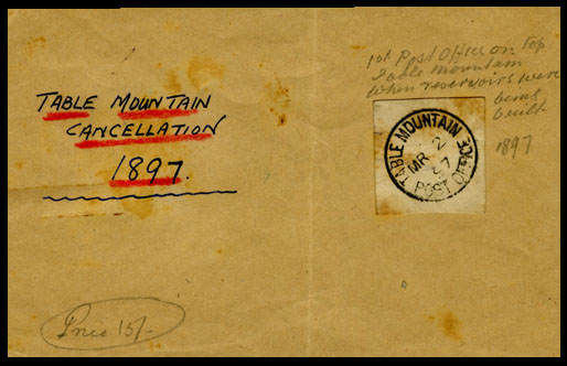
See below, Bob Hill's first 'Table Mountain' postmark of 1893, only the second one known. Bob also owns Ralph Putzel's notes from when he presented this postmark to the 'Royal' in Cape Town, (not to be confused with the Royal Hotel! Been there, done that!). It is also the first South African postmark shown in Volume 1 of Ralph's 'Postmarks of South Africa', one he then described as "the only known copy". I also include an early-ish Table Mountain button badge made of tin and card. Probably from the early 1930s. (The cableway started in 1929.)
Images
1]. 1981. My Cape Town credentials showing part of an A4 cover from Signal Hill Publishing (Pty) Ltd. I can post a photo of me as a baby in the shadow of Devil's Peak in my Ouma's house in Rosebank.
2]. Bob Hill's rare Table Mountain postmark of 1897, used when the reservoirs were being built, apparently.
3]. A Table Moutain Cableway Button Badge.
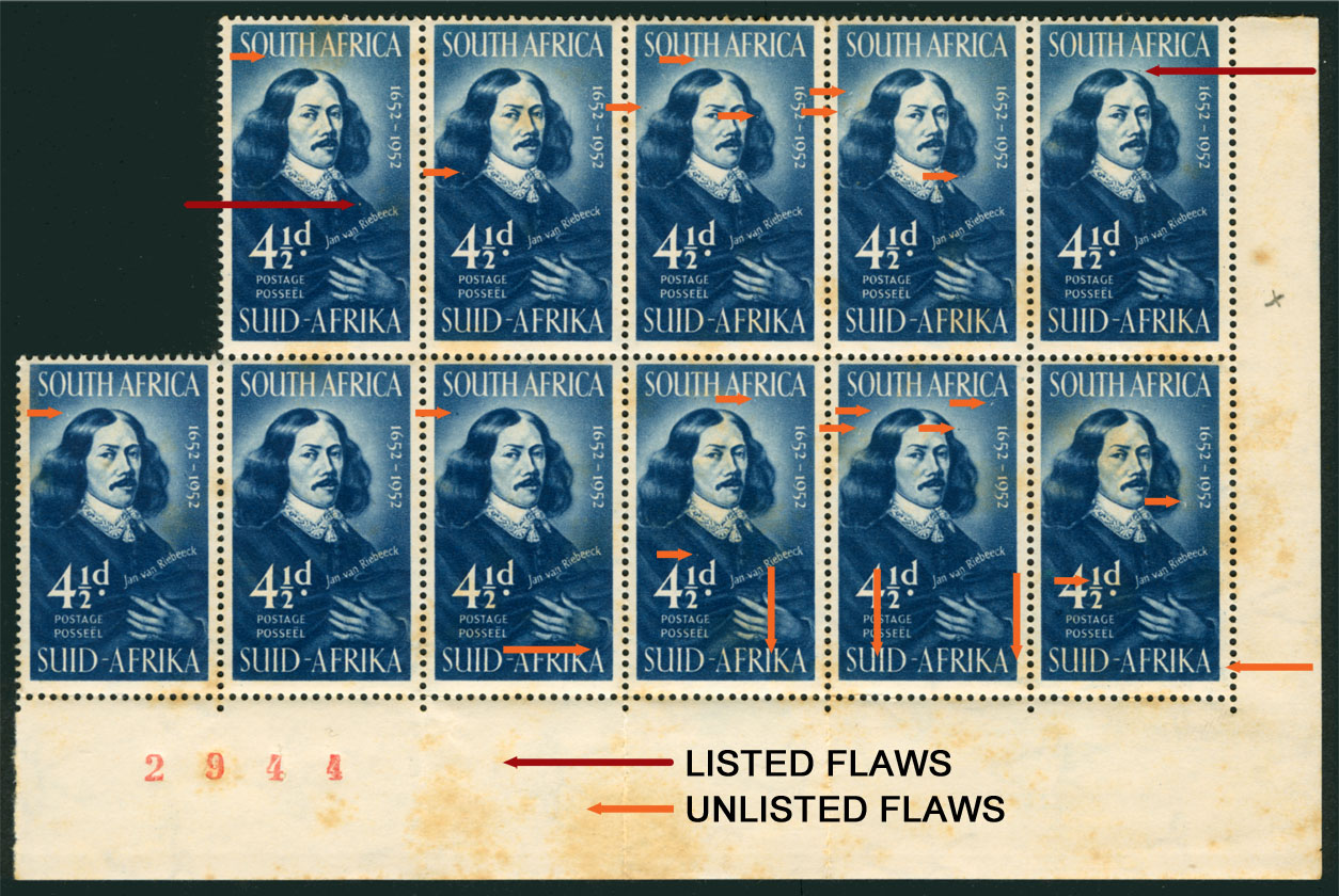
4]. The flawed van Riebeeck. But is it? We now know that this popular image shows another Dutchman.
View Gawie Hugo's 'Table Mountain, the Inspiration' here.
Many a time during my darkest days in Cape Town I sought refuge in walking around the lower foothills and contour paths of Table Mountain. Once, I rounded a bend in a track where water the colour of brandy sparkled sweetly over stones cool from the shade of wild almonds, yellowwoods and Cape olives. There, sitting on a stone dam wall like dryads or naiads in a Mucha art nouveau print, stunningly dappled by shadow and sunlight, were three of the most beautiful 'Coloured' girls, one with a magnificent 'afro', refugees like me from the Mother City's one-sided love. The enchantment of that scene took my breath away. Was it the same for the lonely sons of the first settlers?
Page 1: Table Mountain, the Inspiration
A loose translation of the Dutch in the 'Inscription on the painting' is "In the year 1772 in the month of May, I, Jakob van Renen of the Cape, departed to the fatherland with the ship named Borselen, commanded by Captain Sierevelt and at the same time made this sketch of the ..... above the plate of the bay .... from a ship at the time on the plate ..... Tjiena". The term 'Plaad' or 'plate' seems odd. However, there is a stretch of coastline that runs from Hermanus to Die Kelders just outside Gansbaai that is called 'Die Plaat' (Afr. the sheet). This refers to the long coastal plain that drops considerably just offshore. Sorry, that's the best I can offer.
Page 4. Landing of Jan Anthonisz van Riebeeck 1652.
The pair of stamps shown is the 1952 2d Tercentenary 'Landing of van Riebeeck' as used on the Home page (Ist January 2023). The red arrow on this stamp points to the 'Moon over Table Bay' variety. The 1/- shown alongside is described "Signalhill as the backdrop". This is wrong. It is Devil's Peak in the distance. I speak from experience. I was conceived in the shadow of Devil's Peak in my grandmother's house in Rosebank, its closest suburb. I would recognise it anywhere. Our house in Camp Road, Pinelands, had an unfettered view of Devil's Peak from the living room window. I was so in thrall of Cape Town's mountains that I named my first business Signal Hill Publications (Pty) Ltd., (see part cover below), a use of my initials and a cheeky part rip-off of McGraw Hill. It worked. Some took me seriously!
Page 5: The First Fort
Jan van Riebeeck, the Dutch Commander at the Cape, had been ordered by the VOC (Dutch East India Company) to build a garden, a hospital and a fort in Table Bay beneath the mountain. On page 5, Gawie shows a superb example of this first sod and timber fort (1652 - 1666 when work on the Castle began). The fort was intended to protect Dutch commercial interests from rival foreign powers, as well as the VOC's servants, but once built it became a means of protecting and distancing the Dutch from the indigenous people, the Khoi, as well as the Peninsula's many predators, most especially the magnificent black-maned Table Mountain lion.
Jan, Krotoa, Eva and Oom Paul President Kruger
Jan van Riebeeck initially attempted to build cordial relations with the Khoi with whom the VOC hoped to trade as well as employ. To facilitate communication with the Khoi, he bought into the fort a young Khoi woman, Krotoa, whom he gave the Christian name of 'Eva'. (See page 47). A translator and niece of 'Harry the Hottentot', she married Pieter van Meerhof in 1664, the first Khoi to marry a European and also the first according to Christian customs. The Peltzers, Krugers, Steenkamps and other Afrikaner families are included among her descendants today. The subsequent use of Eva as a racist warning against miscegenation has deliberately ignored van Riebeeck's encouragement of this marriage.
Among a number of other factors, segregation as it has historically been practised by White South Africans probably evolved in the first instance from van Riebeeck excluding the Khoi from the first fort on the basis of growing mistrust once the Khoi withdrew their support and began a campaign of harrassment. A hedge of bitter almonds extended this segregation to the rich and contested farmland along the Liesbeeck River which the Dutch had unilaterally claimed as theirs. As a boy my pals and I would ride our bicycles from Pinelands along the newly built Settlers' Way to the stretch of the Liesbeeck River between Mowbray and the Observatory. At Mowbray there was a run-down farmhouse on the far bank alongside the river where a baboon was kept on a chain It was more frightening than any dog.
Page 8. English Rule.
Gawie's sub-heading has an interesting back-story. The British Empire was driven by English Imperialism against its Celtic neighbours. First the Cornish Britons, then the Welsh fell, followed by the Irish. Finally the Scots begged a Union once their own failed imperial ambition caused national impoverishment. In 1806 when the Batavian Republic's Dutch colony at the Cape was occupied it was by Great Britain, not the English. This is an easy error to make, one I make quite often as a South African and strive to correct.
In South Africa, British rule was interpreted by Boers, today's Afrikaners, as 'English rule'. One of the main reasons for this is that at times English was the only official language, as it presumably was in Wales, Ireland and Scotland at the time. Unlike other colonies, South Africa experienced only limited influence from English-speaking Scottish administrators and educators. However, Scottish clergymen who learned to speak Dutch - and thereby became 'Afrikaners' - had great acceptance in South Africa. Despite get-rich-quick gold South Africa was never a popular immigration destination for the British working class who chose to immigrate to the USA, Canada, Australia and New Zealand. Thus for all of the 19th and for part of the 20th c., English was the language shoved in the faces of Boers, often by English colonial officials. Just as the Welsh, and Scots are quick to resent South Africans calling the UK 'England' today, most are quicker to denounce their shared colonial complicity as the exclusive fault of the English. This is a symptom of a once great country and empire falling apart at the seams.
Page 15. Anglo-Boer War Cover
I have two of these Stellenbosch covers showing the small orange cork canceller, neither of which are going to the OFS - one to Cape Town, the other to Pretoria. That being the case, I disagree with the statement that the small orange cork canceller was used by the Printing Works Censor, Bloemfontein. They were clearly used in a place common to all the covers - Stellenbosch.
As my two Stellenbosch covers have always fascinated me, I am pleased to see another one here. All three are from the South African War era of mid to late 1901. My theory is that the small orange cork canceller was applied in Stellenboch to show that a cover had been censored and was ready for posting. I believe Stellenbosch censorship was heightened at this time due to a]. it having a large Remount Depot and b]. General Smuts' Boer invaders being some 40 miles away 'in die omgewing', (Afr. vicinity). Smuts was born in Malmesbury, a dorp down the road from Stellenbosch where he was educated. I retain an open mind but only just! I will dig mine out and post an addendum about them a bit later.
Page 49 Table Mountain Postmarks.
See below, Bob Hill's first 'Table Mountain' postmark of 1893, only the second one known. Bob also owns Ralph Putzel's notes from when he presented this postmark to the 'Royal' in Cape Town, (not to be confused with the Royal Hotel! Been there, done that!). It is also the first South African postmark shown in Volume 1 of Ralph's 'Postmarks of South Africa', one he then described as "the only known copy". I also include an early-ish Table Mountain button badge made of tin and card. Probably from the early 1930s. (The cableway started in 1929.)
Images
1]. 1981. My Cape Town credentials showing part of an A4 cover from Signal Hill Publishing (Pty) Ltd. I can post a photo of me as a baby in the shadow of Devil's Peak in my Ouma's house in Rosebank.
2]. Bob Hill's rare Table Mountain postmark of 1897, used when the reservoirs were being built, apparently.
3]. A Table Moutain Cableway Button Badge.
4]. The flawed van Riebeeck. But is it? We now know that this popular image shows another Dutchman.
Uploaded files:
Quote from Steve on January 3, 2023, 10:36 amHere are the two examples from Stellenbosch posted during the South African War. As both have the 1893 'Hope Standing showing Table Bay and Mountain', they are germane to this display on Table Mountain.
Along with Gawie's example, the common thread is the Stellenbosch squared circle postmark. The small orange cork mark was almost certainly applied there as was the rectangular red 'PASSED PRESS CENSOR' and the label on the earliest example of 26 August 1901. Both Gawie and I referred to it as a 'cork canceller'. We are both wrong as it does not cancel anything, certainly not a stamp. Strictly speaking, it is a cork identifying mark. But what is its purpose?
The dates of our three covers are: 26 August 1901; 21 September 1901 and 7 November 1901. Interestingly, only the earliest cover has an 'OPENED UNDER MARTIAL LAW." label. Does this mean that by 21st September they had run out of labels or that they were no longer a requirement?
If anyone has another example or knowledge of this, please share it with us on the South African War thread.
I have also posted these two covers in the Cork Canceller thread.
Here are the two examples from Stellenbosch posted during the South African War. As both have the 1893 'Hope Standing showing Table Bay and Mountain', they are germane to this display on Table Mountain.
Along with Gawie's example, the common thread is the Stellenbosch squared circle postmark. The small orange cork mark was almost certainly applied there as was the rectangular red 'PASSED PRESS CENSOR' and the label on the earliest example of 26 August 1901. Both Gawie and I referred to it as a 'cork canceller'. We are both wrong as it does not cancel anything, certainly not a stamp. Strictly speaking, it is a cork identifying mark. But what is its purpose?
The dates of our three covers are: 26 August 1901; 21 September 1901 and 7 November 1901. Interestingly, only the earliest cover has an 'OPENED UNDER MARTIAL LAW." label. Does this mean that by 21st September they had run out of labels or that they were no longer a requirement?
If anyone has another example or knowledge of this, please share it with us on the South African War thread.
I have also posted these two covers in the Cork Canceller thread.
Uploaded files: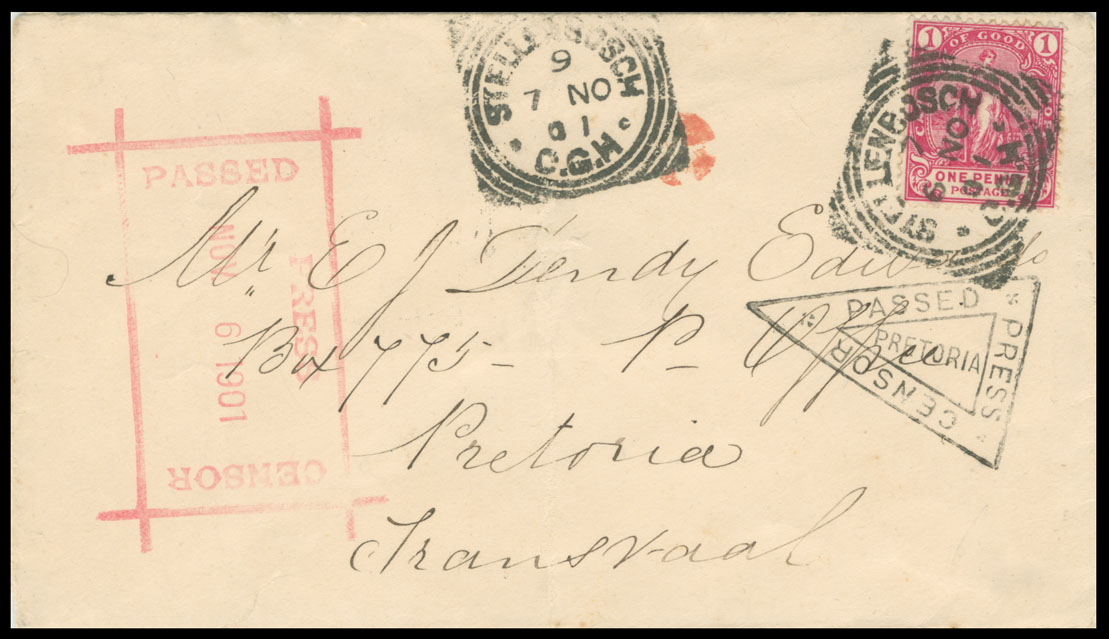
Quote from Steve on January 11, 2023, 12:48 pmCheck out this 'Table Mountain Cover' in the Airmail section.
See: https://southafricanphilatelyclub.com/forum/topic/airmail-first-flight-covers?part=2#postid-5068Further to Bob Hill's 'Table Mountain' postmark of 1897....
In early days of the Dutch settlement, Cape Town was supplied with water that ran freely down from Table Mountain before entering "grachts" (Dutch. canals), like Buitengracht (Outside), Kaizergracht (King's) and Heerengracht (Lord's), all now covered up and major streets within central Cape Town.
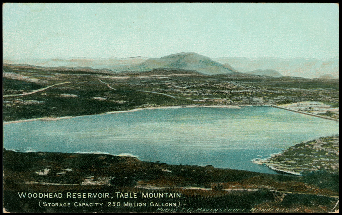
The first serious attempt to supply Cape Town with dammed water from a reservoir was the Molteno Dam on the lower slopes of Table Mountain, established in 1877 in the suburb of what is now Oranjezicht, Cape Town. It was a a formidable engineering challenge for the early Cape, one that soon became inadequate as the city rapidly developed. The Woodhead Reservoir was the first dam to be built on Table Mountain.
Constructed between 1894 and 1897, the Woodhead Reservoir was the first large masonry dam to be built in South Africa. The dam is 252m-long and 44-metres tall at its highest point. Construction of the dam wall initially involved porters carrying building materials by hand up Kasteelpoort Ravine from Camps Bay, a quite incredible feat. I've 'climbed' the mountain by clambering up Kasteelpoort and know just how demanding and dangerous this would have been. Our country was not built by sissies. I defy you to carry a bag of cement on your back up Kasteelpoort!
Given the difficulty of getting vast quantities of building materials and manpower up the ravine, a small, steam-driven cableway,Table Mountain's first, was built in Kasteelpoort Ravine. Once building material reached the summit it was transported by small by locomotive to the Woodhead Reservoir dam site some 2km across the relatively flat Back Table. (The locomotive also had to be gotten to the top of the 1,086 metre or 3,563 ft Table Mountain!) A small 'town' supported the Woodhead Reservoir site with accomodation, a bank, general dealer and a post office.
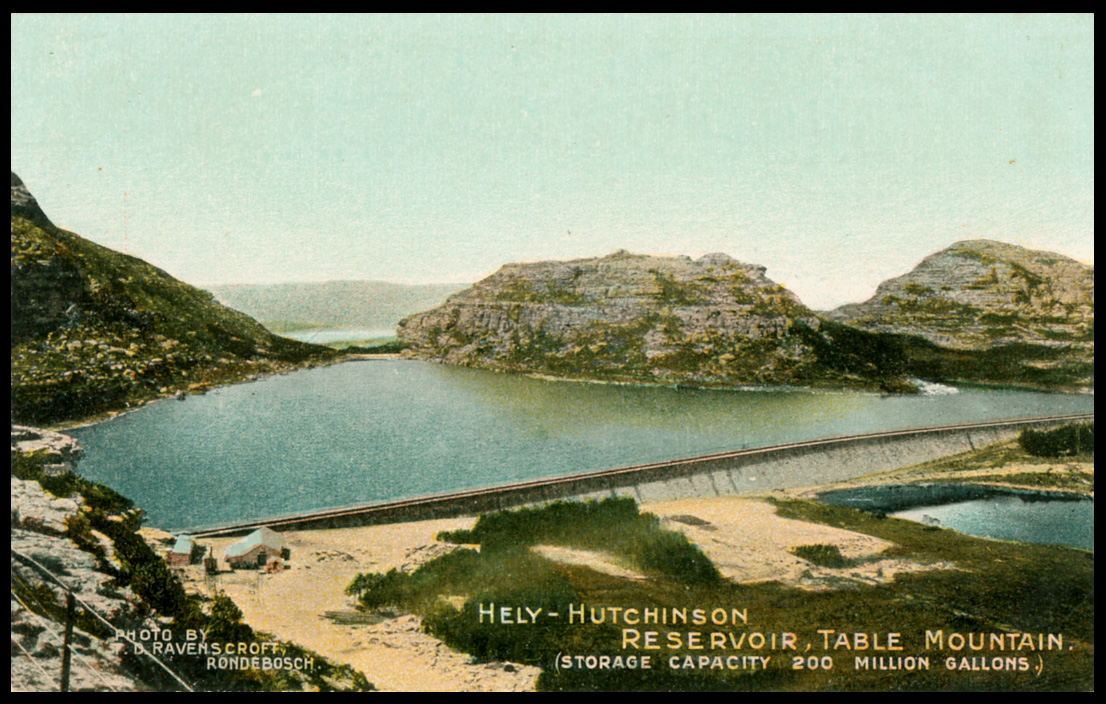
The Woodhead Reservoir did not resolve Cape Town's growing demand for more water. As a result, and using the same means of ferrying manpower and materials up Kasteelpoort Ravine by cableway, work began on the Hely-Hutchinson dam in 1896. This dam was completed in 1904 with a 582m-long wall and a water surface area covering around 16 hectares. However, this still did not satisfy Cape Town's growing need for water. By 1907, there would be five dams on the Back Table, the three newest ones including the De Villiers, Alexandria and Victoria reservoirs.
The anchor points at the old top station can still be seen above Kasteelpoort Ravine. A well-preserved steam locomotive from this period is housed in the Waterworks Museum near the Hely-Hutchinson dam.
Bob Hill's postmark is one of only two known today from the first post office, more likely an agency, on Table Mountain. The absence of more recorded covers is surprising given that the presence of a post office on the mountain suggests a justifiable case for its services based on long term, volume demand. If so, there should be more such postmarks. Perhaps this post office was only a temporary arrangement? Ralph Putzel's example is dated 1893 and Bob Hill's 1897. Both are from the period of the construction of the Woodhead Reservoir. Does this suggest that the post office was not there during the building of the other reservoirs? Perhaps other postal arrangements were then in place?
Top: Woodhead Reservoir.
Bottom: Hely-Hutchinson Reservoir.
Check out this 'Table Mountain Cover' in the Airmail section.
See: https://southafricanphilatelyclub.com/forum/topic/airmail-first-flight-covers?part=2#postid-5068
Further to Bob Hill's 'Table Mountain' postmark of 1897....
In early days of the Dutch settlement, Cape Town was supplied with water that ran freely down from Table Mountain before entering "grachts" (Dutch. canals), like Buitengracht (Outside), Kaizergracht (King's) and Heerengracht (Lord's), all now covered up and major streets within central Cape Town.
The first serious attempt to supply Cape Town with dammed water from a reservoir was the Molteno Dam on the lower slopes of Table Mountain, established in 1877 in the suburb of what is now Oranjezicht, Cape Town. It was a a formidable engineering challenge for the early Cape, one that soon became inadequate as the city rapidly developed. The Woodhead Reservoir was the first dam to be built on Table Mountain.
Constructed between 1894 and 1897, the Woodhead Reservoir was the first large masonry dam to be built in South Africa. The dam is 252m-long and 44-metres tall at its highest point. Construction of the dam wall initially involved porters carrying building materials by hand up Kasteelpoort Ravine from Camps Bay, a quite incredible feat. I've 'climbed' the mountain by clambering up Kasteelpoort and know just how demanding and dangerous this would have been. Our country was not built by sissies. I defy you to carry a bag of cement on your back up Kasteelpoort!
Given the difficulty of getting vast quantities of building materials and manpower up the ravine, a small, steam-driven cableway,Table Mountain's first, was built in Kasteelpoort Ravine. Once building material reached the summit it was transported by small by locomotive to the Woodhead Reservoir dam site some 2km across the relatively flat Back Table. (The locomotive also had to be gotten to the top of the 1,086 metre or 3,563 ft Table Mountain!) A small 'town' supported the Woodhead Reservoir site with accomodation, a bank, general dealer and a post office.
The Woodhead Reservoir did not resolve Cape Town's growing demand for more water. As a result, and using the same means of ferrying manpower and materials up Kasteelpoort Ravine by cableway, work began on the Hely-Hutchinson dam in 1896. This dam was completed in 1904 with a 582m-long wall and a water surface area covering around 16 hectares. However, this still did not satisfy Cape Town's growing need for water. By 1907, there would be five dams on the Back Table, the three newest ones including the De Villiers, Alexandria and Victoria reservoirs.
The anchor points at the old top station can still be seen above Kasteelpoort Ravine. A well-preserved steam locomotive from this period is housed in the Waterworks Museum near the Hely-Hutchinson dam.
Bob Hill's postmark is one of only two known today from the first post office, more likely an agency, on Table Mountain. The absence of more recorded covers is surprising given that the presence of a post office on the mountain suggests a justifiable case for its services based on long term, volume demand. If so, there should be more such postmarks. Perhaps this post office was only a temporary arrangement? Ralph Putzel's example is dated 1893 and Bob Hill's 1897. Both are from the period of the construction of the Woodhead Reservoir. Does this suggest that the post office was not there during the building of the other reservoirs? Perhaps other postal arrangements were then in place?
Top: Woodhead Reservoir.
Bottom: Hely-Hutchinson Reservoir.
Quote from Steve on January 21, 2023, 10:57 amThis is one for the deltiologists (postcard collectors) among you.
The iconic 'Pepper Pots' are three cylindrical towers above the suburb of Vredehoek, (Afr. Peace Corner). Correctly known as Disa Park, these eyesores squat crudely within the bowl of the moutain, a shameful everyday reminder to Capetonians of the poor planning and even worse architecture, (that's too polite!), of the free-for-all boom times of the 1960s when monstrosities like this were deemed worthy and deserving of the word 'progress'. I remember being horrified when I first saw them. It was a time when District 6 was being bull-dozed under Apartheid's Group Areas Act. These 'Whites Only' pepper pots reflected the spiritual ugliness of the time. Why they have not been demolished is a mystery, - and possibly a crime against humanity and aesthetics. They only good thing I can say about them is being so prominent you can use them to date images of the mountain ie. Pre and Post Pepper Pots.
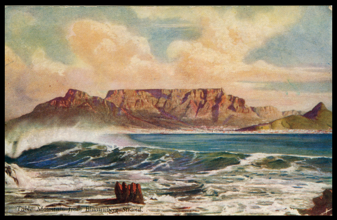
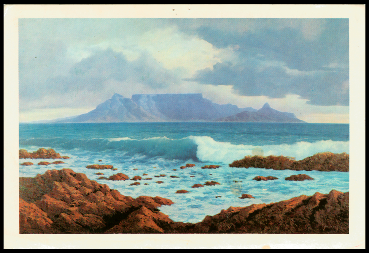
The first image is taken from the United Tobacco Companies' cigarette card album, the 'Tavern of the Seas', circa 1935. Pre Pepper Pots, it shows the Table Mountain massif stretching from Table Bay to Cape Point.
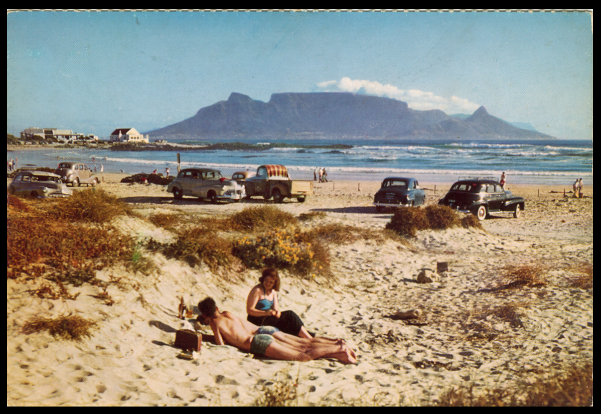
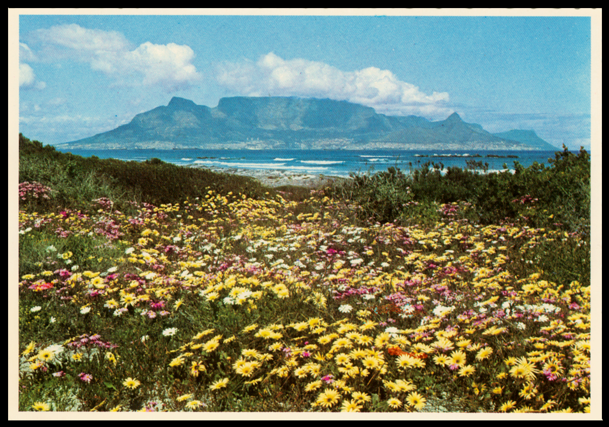
The second, third and fourth postcards below are all Pre-Pepper Pots, all printed or photographed from pretty much the same place on Blouberg Beach (aka Blaauwberg Strands or facetiously, 'Bellville Beach' ). I have always thought these images of a blue Table Mountain are the classic Cape propagandists view. The second image ('Table Mountain from Blaauwberg Strand, 1952 to England) reminded me that as a boy I knew this place as 'Blouberg Strand', not 'Beach'. It is the only image of the mountain that is not brown, not a shade of blue, (Dutch. blaauw. Afr. Blou.). The third, 'Eventide, an original painting by Gerhard Wagner, 1970 to Bedford, Cape), made me wonder if this was the same Corporal Wagner of the Defence Force Printing Unit who designed the frame around Capt. Neville Lewis' portraits for the 1941 -1942 War Effort stamps. The fourth unused postcard ('Blaauwberg, Cape', Terence J. McNally), shows a view in the late 1950s, early 60s, as suggested by that other great dater of time, motor vehicles like Chevrolets, etc.. As I recall, in those days most cars had leather seats that quickly scuffed and wore out!
In the last undated postcard, ('Spring floral beauty at Melkbosstrand with Table Mountain as a natural backdrop', Protea Colour Prints), you can just see the offending Pepper Posts to the bottom right of Devil's Peak. As this postcard is Post Pepper Pot, we can date it to some time after the early 1960s. My guess would be the mid-1980s.
This is one for the deltiologists (postcard collectors) among you.
The iconic 'Pepper Pots' are three cylindrical towers above the suburb of Vredehoek, (Afr. Peace Corner). Correctly known as Disa Park, these eyesores squat crudely within the bowl of the moutain, a shameful everyday reminder to Capetonians of the poor planning and even worse architecture, (that's too polite!), of the free-for-all boom times of the 1960s when monstrosities like this were deemed worthy and deserving of the word 'progress'. I remember being horrified when I first saw them. It was a time when District 6 was being bull-dozed under Apartheid's Group Areas Act. These 'Whites Only' pepper pots reflected the spiritual ugliness of the time. Why they have not been demolished is a mystery, - and possibly a crime against humanity and aesthetics. They only good thing I can say about them is being so prominent you can use them to date images of the mountain ie. Pre and Post Pepper Pots.
The first image is taken from the United Tobacco Companies' cigarette card album, the 'Tavern of the Seas', circa 1935. Pre Pepper Pots, it shows the Table Mountain massif stretching from Table Bay to Cape Point.
The second, third and fourth postcards below are all Pre-Pepper Pots, all printed or photographed from pretty much the same place on Blouberg Beach (aka Blaauwberg Strands or facetiously, 'Bellville Beach' ). I have always thought these images of a blue Table Mountain are the classic Cape propagandists view. The second image ('Table Mountain from Blaauwberg Strand, 1952 to England) reminded me that as a boy I knew this place as 'Blouberg Strand', not 'Beach'. It is the only image of the mountain that is not brown, not a shade of blue, (Dutch. blaauw. Afr. Blou.). The third, 'Eventide, an original painting by Gerhard Wagner, 1970 to Bedford, Cape), made me wonder if this was the same Corporal Wagner of the Defence Force Printing Unit who designed the frame around Capt. Neville Lewis' portraits for the 1941 -1942 War Effort stamps. The fourth unused postcard ('Blaauwberg, Cape', Terence J. McNally), shows a view in the late 1950s, early 60s, as suggested by that other great dater of time, motor vehicles like Chevrolets, etc.. As I recall, in those days most cars had leather seats that quickly scuffed and wore out!
In the last undated postcard, ('Spring floral beauty at Melkbosstrand with Table Mountain as a natural backdrop', Protea Colour Prints), you can just see the offending Pepper Posts to the bottom right of Devil's Peak. As this postcard is Post Pepper Pot, we can date it to some time after the early 1960s. My guess would be the mid-1980s.
Uploaded files: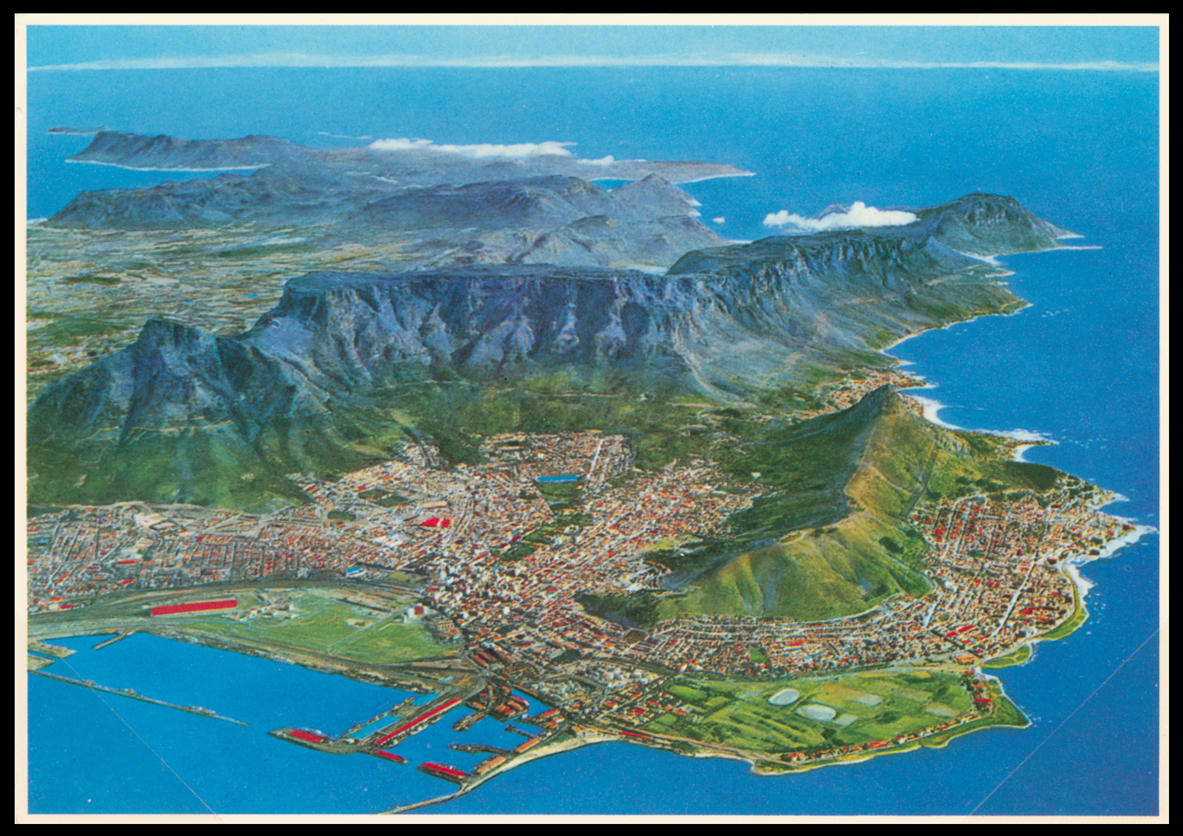
Quote from Steve on January 21, 2023, 3:56 pmOkay, people are moaning, saying thay can't see the Pepper Pots. Here they are on the left, three toilet rolls aka 'Tampon Towers', protruding into the green of Devil's Peak. Prior to their construction Cape Town's mountainside residential accomodation was low-rise. This was rude! The postcard is from PROCOLOR, a photo lab I used at 33 Bree Street when I had my publishing business. I know that I was given this postcard by them in the early 1980s.
Okay, people are moaning, saying thay can't see the Pepper Pots. Here they are on the left, three toilet rolls aka 'Tampon Towers', protruding into the green of Devil's Peak. Prior to their construction Cape Town's mountainside residential accomodation was low-rise. This was rude! The postcard is from PROCOLOR, a photo lab I used at 33 Bree Street when I had my publishing business. I know that I was given this postcard by them in the early 1980s.
Uploaded files: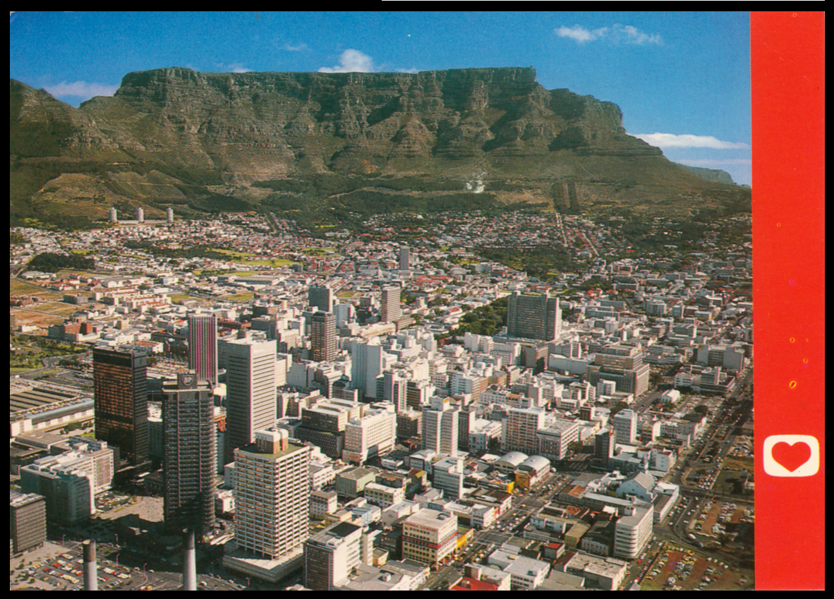
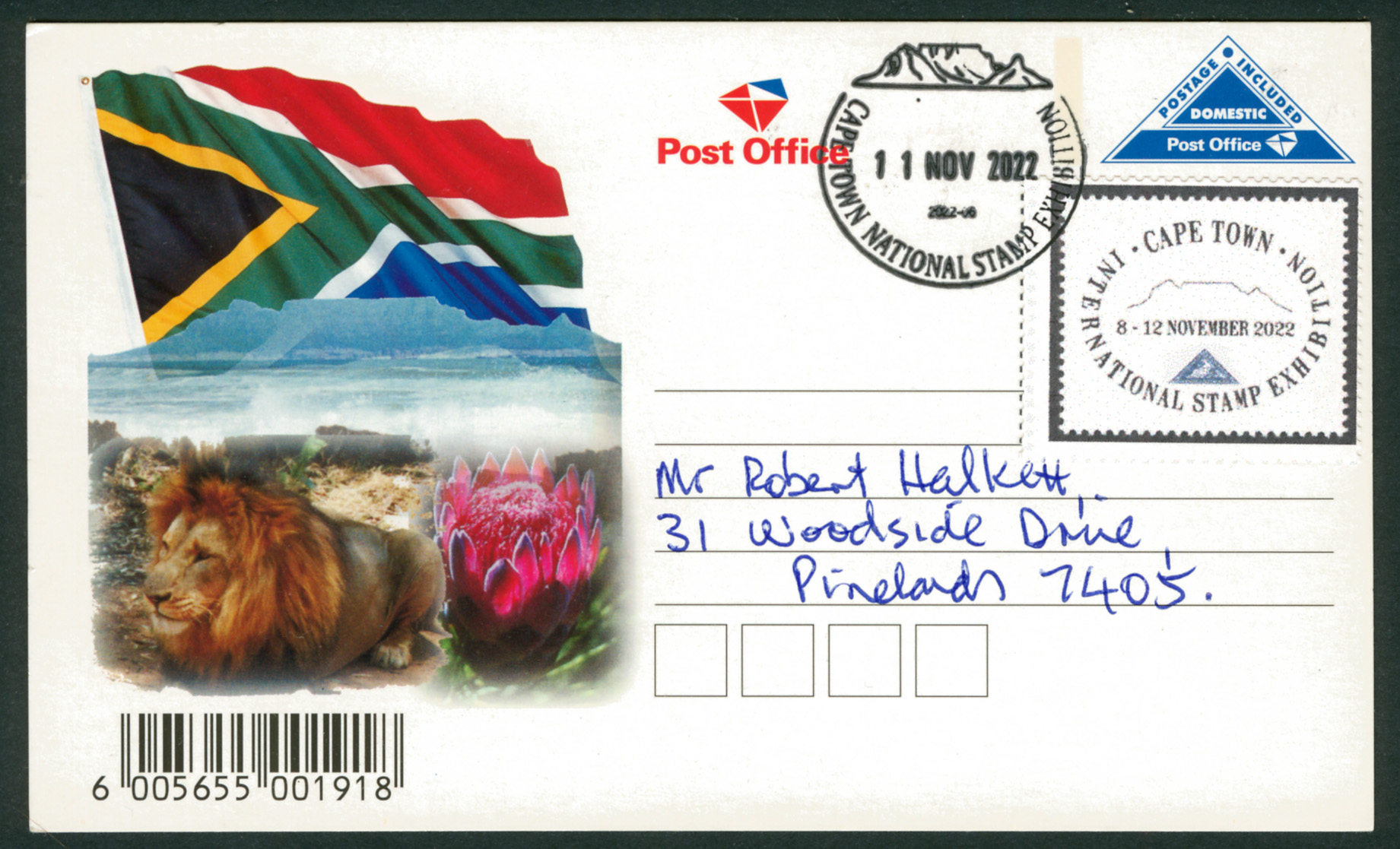
Quote from Steve on June 23, 2023, 11:17 amHere are two new acquisitions, one a curiosity, the other from a Cape Town Stamp Exhibition in 2022.
I bought the top cover on eBay recently. I have two theories as to why a cover with a GB stamp bears a relatively common TABLE MOUNTAIN datestamp, Putzel's No. 4a without Time Code Letter.
My guess is that a party from a mail or cruise ship came ashore and went up Table Mountain, perhaps as part of an excusrion organised by a local tour guide with Post Office connections. This cover was stamped on Table Mountain and returned to the ship where it went into the Paquebot mail bag. (I am unaware of a Paquebot service being run from Table Mountain but it would seem sensible to offer that facility there.) Once in the mail bag it was brought ashore again and accepted as standard Paquebot mail. It was not given a standard Paquebot mark because it was already cancelled. Alternatively, after per favour cancelling on Table Mountain where it was not accepted because no Paquebot system operated there, it went back to the ship and was never posted. This is inconclusively supported by an absence of a GB receiving mark and the fact that the cover is relatively pristine.
I asked Jamie Smith, the SAPC's co-founder and resident GB expert, what he made of it. He replied. "An expert is a drip under pressure! I think it has been cancelled to order but not sent. You would not expect a British receiving strike in any case, usually only on Registered mail. As far as I know the only time that a British stamp was acceptable was either as you say Paquebot or at Simon's Town with the Royal Navy 'OR' at the Hydrographer's office in the Observatory. The alternative is it may have been done by a sailor who thought it was acceptable and had already placed the stamp on and the counter staff did him a favour. Take your pick!"
The bottom postcard was posted from the Cape Town International Stamp Exhibition on 11 Nov 2022. The 'DOMESTIC' rate postcard is postal stationery presumably printed for the event. More of these postcards will no doubt begin to appear in future. It is too modern to be listed in Putzel but I was surprised to see that it is not included in Alex Visser's on-line Addendum. It's a new discovery! :>)
Here are two new acquisitions, one a curiosity, the other from a Cape Town Stamp Exhibition in 2022.
I bought the top cover on eBay recently. I have two theories as to why a cover with a GB stamp bears a relatively common TABLE MOUNTAIN datestamp, Putzel's No. 4a without Time Code Letter.
My guess is that a party from a mail or cruise ship came ashore and went up Table Mountain, perhaps as part of an excusrion organised by a local tour guide with Post Office connections. This cover was stamped on Table Mountain and returned to the ship where it went into the Paquebot mail bag. (I am unaware of a Paquebot service being run from Table Mountain but it would seem sensible to offer that facility there.) Once in the mail bag it was brought ashore again and accepted as standard Paquebot mail. It was not given a standard Paquebot mark because it was already cancelled. Alternatively, after per favour cancelling on Table Mountain where it was not accepted because no Paquebot system operated there, it went back to the ship and was never posted. This is inconclusively supported by an absence of a GB receiving mark and the fact that the cover is relatively pristine.
I asked Jamie Smith, the SAPC's co-founder and resident GB expert, what he made of it. He replied. "An expert is a drip under pressure! I think it has been cancelled to order but not sent. You would not expect a British receiving strike in any case, usually only on Registered mail. As far as I know the only time that a British stamp was acceptable was either as you say Paquebot or at Simon's Town with the Royal Navy 'OR' at the Hydrographer's office in the Observatory. The alternative is it may have been done by a sailor who thought it was acceptable and had already placed the stamp on and the counter staff did him a favour. Take your pick!"
The bottom postcard was posted from the Cape Town International Stamp Exhibition on 11 Nov 2022. The 'DOMESTIC' rate postcard is postal stationery presumably printed for the event. More of these postcards will no doubt begin to appear in future. It is too modern to be listed in Putzel but I was surprised to see that it is not included in Alex Visser's on-line Addendum. It's a new discovery! :>)
Uploaded files: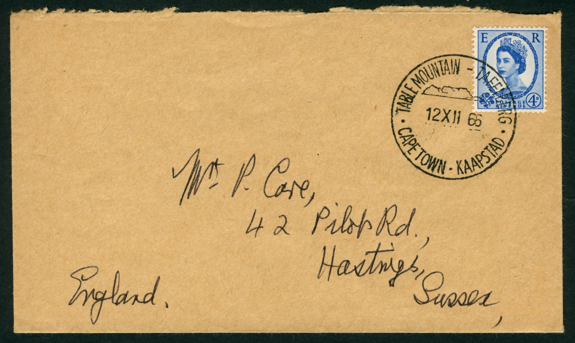
Quote from Jamie Smith on June 23, 2023, 12:17 pmSteve, This is all I have but I still like your cover!
I do have other paquebot covers but can't find them - I will check and post later.
Steve, This is all I have but I still like your cover!
I do have other paquebot covers but can't find them - I will check and post later.
Uploaded files:
Quote from Steve on October 25, 2025, 3:39 pmCape Town and Table Mountain would be nothing without the sea. Here are two views which reference the profound influence the sea has had in bringing people and imported goods to South Africa, also as a means of exporting our mineral wealth, wines and wool, all against a backdrop of Table Mountain, ('Hoerikwaggo', 'the mountain in the sea' to the Khoi people, the Cape's orginal inhabitants).
1944. SA Reserve Bank £1 note. Van Riebeeck, European settlement, colonisation, industrialisation. Wealth!
1902. Magazine illustration.
HMS 'Good Hope' brings British Colonial Secretary Joe Chamberlain to Cape Town.
In 1902 Chamberlain and his wife journeyed to SA to view the fruits of his aggresive imperialism.Joseph Chamberlain (1836 - 1914) was a British industrialist turned politician, the Secretary of State for the Colonies between 1895 and 1903. After the end of the South African War (aka Anglo-Boer War), Chamberlain sailed to Cape Town on HMS Good Hope. He bore a major responsibility for causing the war and Kitchener's 'methods of barbarism' from which 26,000 Boer women and children died, also 16,000 Black South African deaths, in concentration camps. He traveled the country between 26th December 1902 and 25th February 1903 attempting to foster unity in South Africa within the British Empire. His message of Peace, Prosperity, Goodwill and Union was a bitter pill for many Boers to swallow at a time of martial law and little or no assistance in restoring their ruined properties and lives,
The armoured cruiser HMS Good Hope was originally to be called HMS Africa. She was launched in 1902 at the end of the South African War. She transported Chamberlain and his wife to Cape Town on a goodwill mission. At the outset of the First World War she was sunk will all hands at the Battle of Coronel, Chile, by German ships of their East Asia Squadron under the command of Vice Admiral Graf von Spee. When they heard the news of the British disaster, the worst in 100 years for the Royal Navy, many unreconciled Boers who were soon to rise up in Republican rebellion loudly muttered that they wished that Chamberlain was still aboard.
Cape Town and Table Mountain would be nothing without the sea. Here are two views which reference the profound influence the sea has had in bringing people and imported goods to South Africa, also as a means of exporting our mineral wealth, wines and wool, all against a backdrop of Table Mountain, ('Hoerikwaggo', 'the mountain in the sea' to the Khoi people, the Cape's orginal inhabitants).

1944. SA Reserve Bank £1 note. Van Riebeeck, European settlement, colonisation, industrialisation. Wealth!

1902. Magazine illustration.
HMS 'Good Hope' brings British Colonial Secretary Joe Chamberlain to Cape Town.
In 1902 Chamberlain and his wife journeyed to SA to view the fruits of his aggresive imperialism.
Joseph Chamberlain (1836 - 1914) was a British industrialist turned politician, the Secretary of State for the Colonies between 1895 and 1903. After the end of the South African War (aka Anglo-Boer War), Chamberlain sailed to Cape Town on HMS Good Hope. He bore a major responsibility for causing the war and Kitchener's 'methods of barbarism' from which 26,000 Boer women and children died, also 16,000 Black South African deaths, in concentration camps. He traveled the country between 26th December 1902 and 25th February 1903 attempting to foster unity in South Africa within the British Empire. His message of Peace, Prosperity, Goodwill and Union was a bitter pill for many Boers to swallow at a time of martial law and little or no assistance in restoring their ruined properties and lives,
The armoured cruiser HMS Good Hope was originally to be called HMS Africa. She was launched in 1902 at the end of the South African War. She transported Chamberlain and his wife to Cape Town on a goodwill mission. At the outset of the First World War she was sunk will all hands at the Battle of Coronel, Chile, by German ships of their East Asia Squadron under the command of Vice Admiral Graf von Spee. When they heard the news of the British disaster, the worst in 100 years for the Royal Navy, many unreconciled Boers who were soon to rise up in Republican rebellion loudly muttered that they wished that Chamberlain was still aboard.
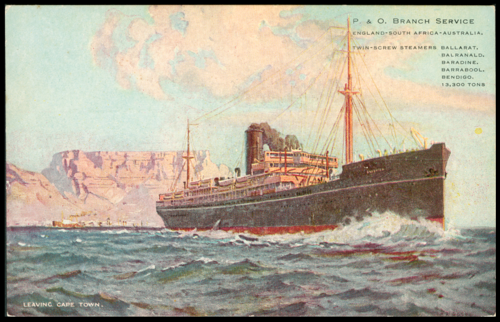
Quote from Steve on October 27, 2025, 10:43 amSticking with images of Table Mountain, Ships and the Sea.....
Circa 1928. Postcard. 'Leaving Cape Town'. (P. & O. Branch Service.)
This is presumably Baradine leaving Cape Town bound for Australia.It's Cape Town, of course, but which ship is it? I suspect Baradine, named after a town in northeast New South Wales, Australia. Launched in 1921, Baradine was the first of the post-WW1 ‘B’ class vessels to enlarge the P&O Branch Line emigrant service via the Cape to Australia. Her maiden voyage was on 21 09 1921. She remained on the Cape route until 1929, despite reduced emigrant traffic after 1926.
Circa 1930. Real Photo Postcard. 'Unused and unidentified by publisher'.
'Otranto' is just visible on the upper prow of the ship.
(ex the Postcard Collection of R. M. Scott, Sea Point, Cape Town.RMS (Royal Mail Ship) Otranto was an ocean liner built for the Orient Steam Navigation Company in 1925. She carried overseas mail to Australia under a contract between Orient Line and Royal Mail. She was named after the town of Otranto in Apulia in southern Italy. Otranto had a long career. In WW2 she was converted into a troop ship and a landing ship, taking part in the invasions of French North Africa, Sicily and Italy. In February 1957 she sailed via Cape Town to Sydney, Australia, where she was sold for scrap.
Circa 1926. Real Photo Postcard. 'Unused and unidentified by publisher'.
Annotated on the reverse 'RMSP Orca, C.T. 1926?'This certainly looks like RMSP Orca in Cape Town but ....the RMSP (Royal Mail Steam Packet Co.) Orca was launched for the Pacific Steam Navigation Co. in 1918 and as a cargo ship. After war service she was eventually refitted as a passenger liner in 1922 and sold to the Royal Mail Steam Packet Co. She sailed on her maiden voyage from Hamburg to New York in 1923. She was sold four years later to the White Star Line and renamed Calgaric. The Depression slump caused her early scrapping in 1934.
Sticking with images of Table Mountain, Ships and the Sea.....
 Circa 1928. Postcard. 'Leaving Cape Town'. (P. & O. Branch Service.)
This is presumably Baradine leaving Cape Town bound for Australia.
It's Cape Town, of course, but which ship is it? I suspect Baradine, named after a town in northeast New South Wales, Australia. Launched in 1921, Baradine was the first of the post-WW1 ‘B’ class vessels to enlarge the P&O Branch Line emigrant service via the Cape to Australia. Her maiden voyage was on 21 09 1921. She remained on the Cape route until 1929, despite reduced emigrant traffic after 1926.

Circa 1930. Real Photo Postcard. 'Unused and unidentified by publisher'.
'Otranto' is just visible on the upper prow of the ship.
(ex the Postcard Collection of R. M. Scott, Sea Point, Cape Town.
RMS (Royal Mail Ship) Otranto was an ocean liner built for the Orient Steam Navigation Company in 1925. She carried overseas mail to Australia under a contract between Orient Line and Royal Mail. She was named after the town of Otranto in Apulia in southern Italy. Otranto had a long career. In WW2 she was converted into a troop ship and a landing ship, taking part in the invasions of French North Africa, Sicily and Italy. In February 1957 she sailed via Cape Town to Sydney, Australia, where she was sold for scrap.

Circa 1926. Real Photo Postcard. 'Unused and unidentified by publisher'.
Annotated on the reverse 'RMSP Orca, C.T. 1926?'
This certainly looks like RMSP Orca in Cape Town but ....the RMSP (Royal Mail Steam Packet Co.) Orca was launched for the Pacific Steam Navigation Co. in 1918 and as a cargo ship. After war service she was eventually refitted as a passenger liner in 1922 and sold to the Royal Mail Steam Packet Co. She sailed on her maiden voyage from Hamburg to New York in 1923. She was sold four years later to the White Star Line and renamed Calgaric. The Depression slump caused her early scrapping in 1934.