
Bellevue POW Camp
Quote from Steve on November 19, 2023, 1:45 pmI recently showed my 'Simonstown' postal history display at the South African Philatelic Society's Conference in Meriden, England, (4th 5th November 2023). It was well-received and I will post it here shortly once I have added a few new pages and sorted a few things out. Various attendees provided helpful comments, especially Ian Shapiro (the scarcity of Soldier and Sailor's Penny Rate Registered Mail), David Morrison (briefstok mail in and around the Cape Town environs) and Tony H-G (a Cape accounting mark). Thank you!
Richard Stroud RDPSA, an authority on the SAW (South African War) and the doyen of the Anglo-Boer War Philatelic Society was interested in my Bellevue Prisoner of War Camp items. He asked me if I was aware of South Camp, the first POW camp in Simonstown which stood near the Martello Tower on the Navy Sports Ground. I was not. As I knew nothing of South Camp, Richard kindly bought me up to speed by sharing with me two articles he has written on the Simonstown POW camps, one published, the other in draft. By return I shared my newly discovered photo of Bellevue POW Camp below, as well as a letter written by Captain J Perkins, its commander.
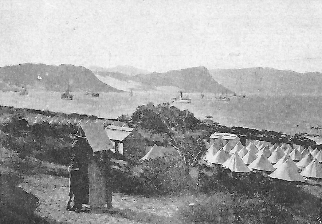
What intrigued me most in Richard's articles was a photo that claimed to be of Bellevue POW Camp. It was described as '"The following illustration is of a lonely guard at the entrance to Belle Vue Camp from the main road above the Camp". See first image below. My main problem with this cllain that it showed Bellevue POW Camp was that from my boyhood holidays in Simonstown I remembered that it was not possible to see Simon's Bay from the Boulders Beach or the Golf Course where Bellevue is thought to have been.
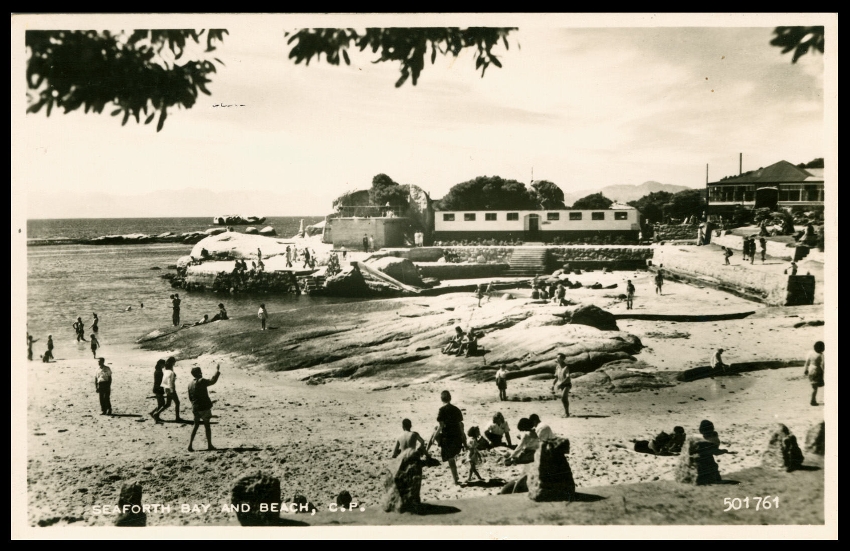
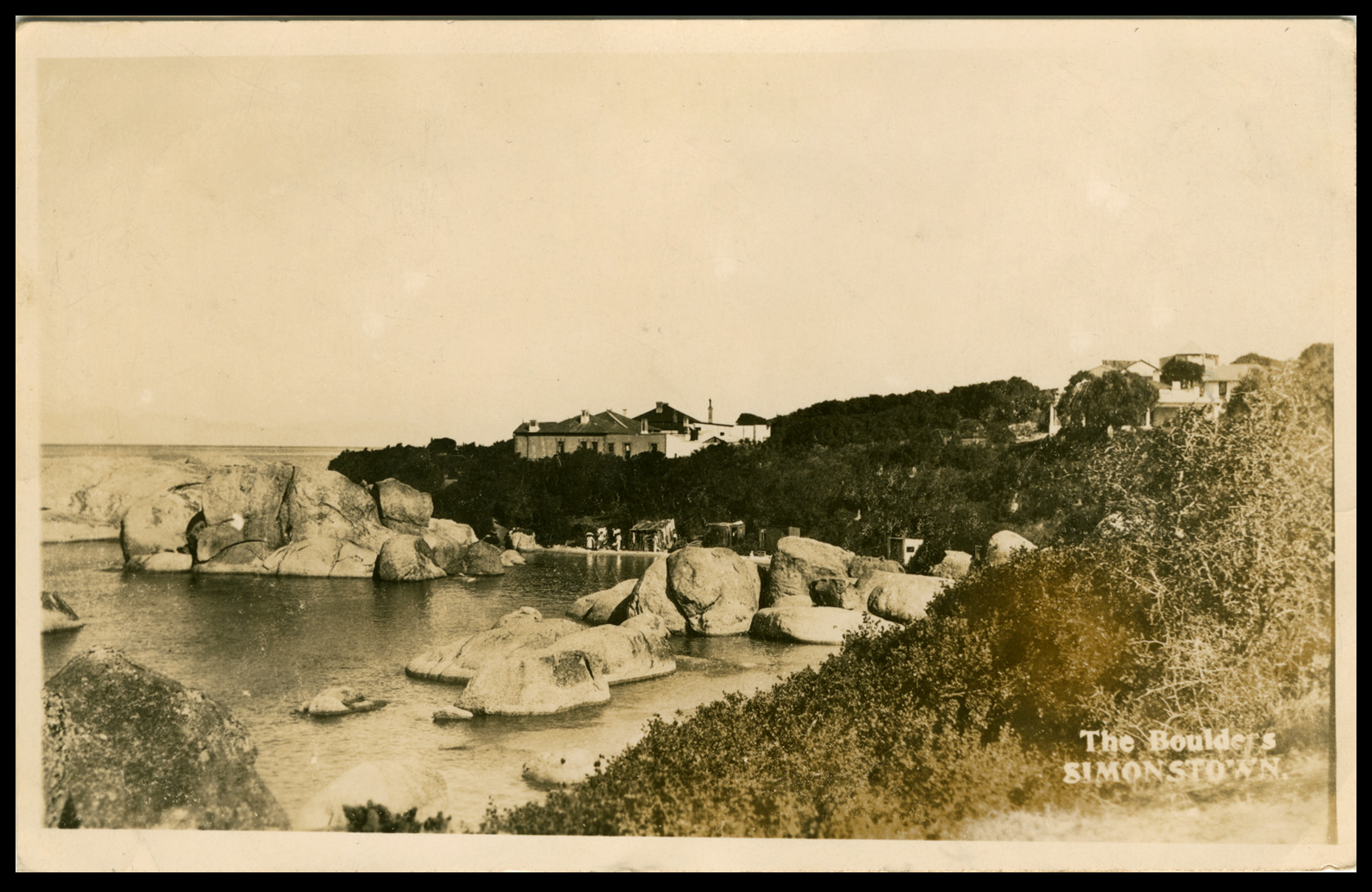
I have presented the five images below from North to South in the order of Simons Bay (photo 'Lonely guard'), Simons Bay (postcard Martello Tower) and following the coast the three bathing beaches of Seaforth (late 1950s postcard), Boulders (circa 1920s postcard) and most southerly of all my recently discovered real photo postcard of Bellevue Camp opposite Windmill Beach, circa 1900. This is provenanced with the monogram of 'L Jenks, (Photographer), Simonstown'. I have other photo postcards by Jenks with a similar mark.
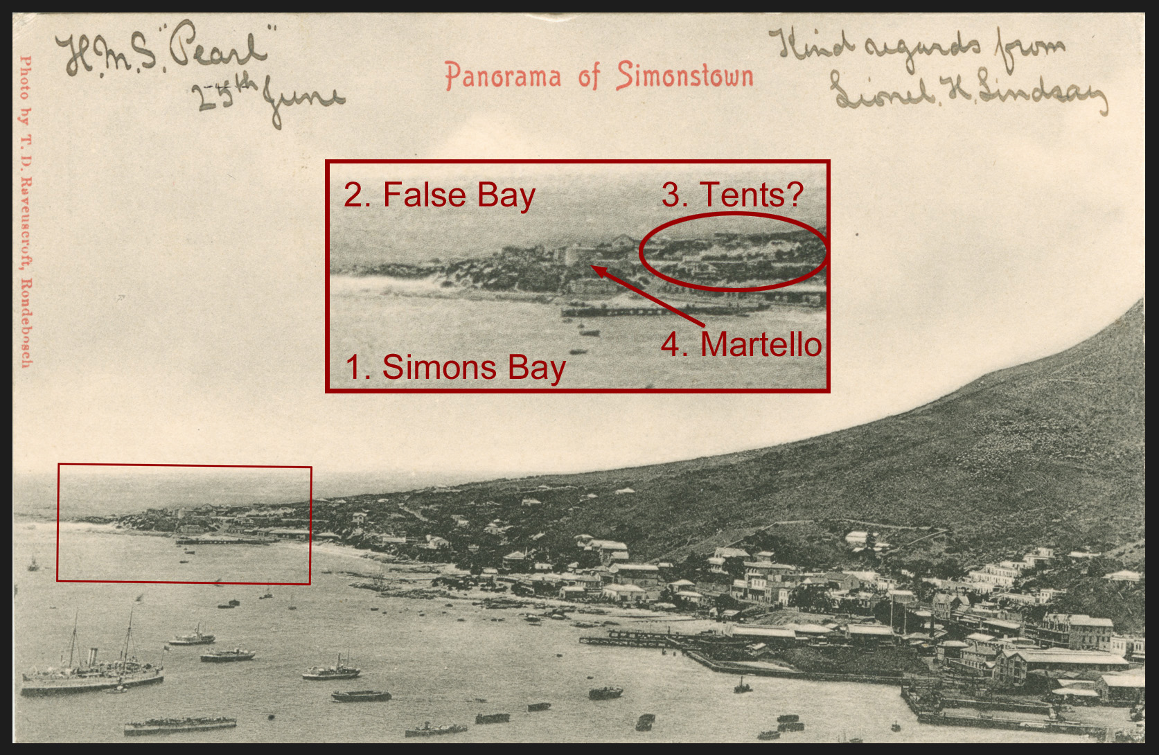
Following Richard's advice I dug out a few Simonstown postcards that showed the area around the Martello Tower. Usually this area is at the further end of any view of Simons's Bay, the detail usually being far too small to be of any use. However, much to my surprise, in the first postcard (second image) reproduced below I was not only able to see the Martello tower but also the Navy Sports Ground which quite incredibly seemied dotted with tents. Was this South Camp, I wondered? I dismissed this idea because the bay was not as busy with ships as it was at the start of the war when Simonstown teemed with transports and warships. So, no, not South POW Camp but most likely, if they were tents, that this was just a temporary camp, either naval or other, but not a wartime one.
My recently purchased real photo postcard is remarkable for showing the full length of Bellevue POW camp. The photo was presumably taken from below the Main Roadat some distance from the camp. The view looks down towards the POW camp which runs more-or-less parallel to the shore. It is set on the area that is a golf course today. I sent a copy to Richard who replied he would work to confirm its location. My boyhood days in the Aloes, a boarding house at the Boulders, Simonstown left me feeing that I already knew where it was.
Bellevue Camp is recorded as having direct access to Windmill Beach where POWs bathed in the nude. On Tuesday 30th July 1901 John Chandler, a 'Boer with an 'Anglo' name', a well-built 29-year-old male from Ladybrand, Orange Free, prisoner number 5316, was fatally attacked by a shark, almost certainly a great white, in the water 10 metres off Windmill Beach which lies below today's golf course.
Unfortunately, the light over many years has faded Jenks' original image. The sky and sea have largely merged and the distant mountains across False Bay have totally disappeared. I have made two views, the first the actual original real photo postcard that I bought which I show below and a second, an enlarged section of the camp scanned at a higher resolution, in the next post.
Alan Macgregor, the South African arm of the stamp dealership Deverill Macgregor, lives in Simonstown close to the golf course. I had previously been in email communication with Alan about the location of the camp and I knew my new photo would interest him. I emailed it to him and asked him if he could use it to confirm the camp's position with a few photos. I thought that the rather obvious rocks off-shore would provide a useful guide. This proved to be more difficult than I thought as it now looks like the photo was taken during a spring low tide which made the rocks appear bigger. We agreed that the camp lay on the golf course close to the shore.
This thread continues.....
Images
1].
2]. Postcard of Simon's Bay with inset view of the 'Naval Sports Ground' with tents. This is the location of South Camp, the first POW camp in Simonstown. This postcards shows that one cannot see Seaforth, Boulders or Windmill Beach (Bellvue) beyond the rise. Equally, if one is on the far side of the rise at less than 100 feet above sea level, one cannot see Simon's Bay. Therefore, any image that shows a view of a tented area with ships in Simon's Bay in the background cannot be Bellevue POW Camp. It must be South Camp.
3]. Postcard of Seaforth in the late 50s, early 60s. (Seaforth Bay and Beach, C. P.) This is the first popular bathing beach after the Naval Dockyard. Although much built up by the time this photo was taken after WW2, it bears little no resemblance to the photo of POWs on the sandy prominitory which I will show later. Boulders lies some short distance down the coast and Bellevue beyond that again. You cannot see Boulders or Bellevue from here and vice versa.
4]. Continuing to proceed down the coast the next real photo postcard is of 'The Boulders, Simonstown', probably circa 1920. I knew this place intimately in the 1960s before the penguins moved in. (It was still too wild for them to live on-shore then). The Aloes where we stayed is the second house along on the left. The commander of the Bellevue POW Camp, lived in one of the houses shown here. Bellevue POW Camp lies hidden behind the ridge on which the houses stand. As a result, you cannot see Simon's Bay from Bellevue.
5]. Now, coming to Bellevue POW Camp opposite Windmill Beach. This is the full real photo postcard that I bought on-line. The camp, which appears to lie close to the coast, is full of men, prisoners of war. This photo was probably taken some time in 1900 when the subject was fresh and topical. Several geological features are prominent.
a]. Rocks North - a large group close in shore left left of centre.
b]. Rocks x 3 - three rocks off-shore left of centre.
c]. Promonitory - right of centre between the camp and the sea.
d]. Rocks South - a large rock off-shore at the far right of the image.
e]. Foreground boulders - these were cleared away in the 1960s to make way for the golf course.
I recently showed my 'Simonstown' postal history display at the South African Philatelic Society's Conference in Meriden, England, (4th 5th November 2023). It was well-received and I will post it here shortly once I have added a few new pages and sorted a few things out. Various attendees provided helpful comments, especially Ian Shapiro (the scarcity of Soldier and Sailor's Penny Rate Registered Mail), David Morrison (briefstok mail in and around the Cape Town environs) and Tony H-G (a Cape accounting mark). Thank you!
Richard Stroud RDPSA, an authority on the SAW (South African War) and the doyen of the Anglo-Boer War Philatelic Society was interested in my Bellevue Prisoner of War Camp items. He asked me if I was aware of South Camp, the first POW camp in Simonstown which stood near the Martello Tower on the Navy Sports Ground. I was not. As I knew nothing of South Camp, Richard kindly bought me up to speed by sharing with me two articles he has written on the Simonstown POW camps, one published, the other in draft. By return I shared my newly discovered photo of Bellevue POW Camp below, as well as a letter written by Captain J Perkins, its commander.
What intrigued me most in Richard's articles was a photo that claimed to be of Bellevue POW Camp. It was described as '"The following illustration is of a lonely guard at the entrance to Belle Vue Camp from the main road above the Camp". See first image below. My main problem with this cllain that it showed Bellevue POW Camp was that from my boyhood holidays in Simonstown I remembered that it was not possible to see Simon's Bay from the Boulders Beach or the Golf Course where Bellevue is thought to have been.
I have presented the five images below from North to South in the order of Simons Bay (photo 'Lonely guard'), Simons Bay (postcard Martello Tower) and following the coast the three bathing beaches of Seaforth (late 1950s postcard), Boulders (circa 1920s postcard) and most southerly of all my recently discovered real photo postcard of Bellevue Camp opposite Windmill Beach, circa 1900. This is provenanced with the monogram of 'L Jenks, (Photographer), Simonstown'. I have other photo postcards by Jenks with a similar mark.
Following Richard's advice I dug out a few Simonstown postcards that showed the area around the Martello Tower. Usually this area is at the further end of any view of Simons's Bay, the detail usually being far too small to be of any use. However, much to my surprise, in the first postcard (second image) reproduced below I was not only able to see the Martello tower but also the Navy Sports Ground which quite incredibly seemied dotted with tents. Was this South Camp, I wondered? I dismissed this idea because the bay was not as busy with ships as it was at the start of the war when Simonstown teemed with transports and warships. So, no, not South POW Camp but most likely, if they were tents, that this was just a temporary camp, either naval or other, but not a wartime one.
My recently purchased real photo postcard is remarkable for showing the full length of Bellevue POW camp. The photo was presumably taken from below the Main Roadat some distance from the camp. The view looks down towards the POW camp which runs more-or-less parallel to the shore. It is set on the area that is a golf course today. I sent a copy to Richard who replied he would work to confirm its location. My boyhood days in the Aloes, a boarding house at the Boulders, Simonstown left me feeing that I already knew where it was.
Bellevue Camp is recorded as having direct access to Windmill Beach where POWs bathed in the nude. On Tuesday 30th July 1901 John Chandler, a 'Boer with an 'Anglo' name', a well-built 29-year-old male from Ladybrand, Orange Free, prisoner number 5316, was fatally attacked by a shark, almost certainly a great white, in the water 10 metres off Windmill Beach which lies below today's golf course.
Unfortunately, the light over many years has faded Jenks' original image. The sky and sea have largely merged and the distant mountains across False Bay have totally disappeared. I have made two views, the first the actual original real photo postcard that I bought which I show below and a second, an enlarged section of the camp scanned at a higher resolution, in the next post.
Alan Macgregor, the South African arm of the stamp dealership Deverill Macgregor, lives in Simonstown close to the golf course. I had previously been in email communication with Alan about the location of the camp and I knew my new photo would interest him. I emailed it to him and asked him if he could use it to confirm the camp's position with a few photos. I thought that the rather obvious rocks off-shore would provide a useful guide. This proved to be more difficult than I thought as it now looks like the photo was taken during a spring low tide which made the rocks appear bigger. We agreed that the camp lay on the golf course close to the shore.
This thread continues.....
Images
1].
2]. Postcard of Simon's Bay with inset view of the 'Naval Sports Ground' with tents. This is the location of South Camp, the first POW camp in Simonstown. This postcards shows that one cannot see Seaforth, Boulders or Windmill Beach (Bellvue) beyond the rise. Equally, if one is on the far side of the rise at less than 100 feet above sea level, one cannot see Simon's Bay. Therefore, any image that shows a view of a tented area with ships in Simon's Bay in the background cannot be Bellevue POW Camp. It must be South Camp.
3]. Postcard of Seaforth in the late 50s, early 60s. (Seaforth Bay and Beach, C. P.) This is the first popular bathing beach after the Naval Dockyard. Although much built up by the time this photo was taken after WW2, it bears little no resemblance to the photo of POWs on the sandy prominitory which I will show later. Boulders lies some short distance down the coast and Bellevue beyond that again. You cannot see Boulders or Bellevue from here and vice versa.
4]. Continuing to proceed down the coast the next real photo postcard is of 'The Boulders, Simonstown', probably circa 1920. I knew this place intimately in the 1960s before the penguins moved in. (It was still too wild for them to live on-shore then). The Aloes where we stayed is the second house along on the left. The commander of the Bellevue POW Camp, lived in one of the houses shown here. Bellevue POW Camp lies hidden behind the ridge on which the houses stand. As a result, you cannot see Simon's Bay from Bellevue.
5]. Now, coming to Bellevue POW Camp opposite Windmill Beach. This is the full real photo postcard that I bought on-line. The camp, which appears to lie close to the coast, is full of men, prisoners of war. This photo was probably taken some time in 1900 when the subject was fresh and topical. Several geological features are prominent.
a]. Rocks North - a large group close in shore left left of centre.
b]. Rocks x 3 - three rocks off-shore left of centre.
c]. Promonitory - right of centre between the camp and the sea.
d]. Rocks South - a large rock off-shore at the far right of the image.
e]. Foreground boulders - these were cleared away in the 1960s to make way for the golf course.
Quote from Steve on November 19, 2023, 2:18 pmFirst, a photo of me, standing outside the Aloes with my catch, about 1961. I am not proud of myself today for ending this poor creature's life. That said, a much larger shark took the species' primordial revenge by scaring me witless a few years later when I was spearfishing at Miller's Point with my pal Keith Ralph who has now cage-dived with great whites at Gansbaai. Shark-filled water are not for me, thank you!
The real reason for showing this is that my back is to Boulders Beach, Seaforth and Simon's Bay, neither of which you can see from where I am standing in the elevated car park of The Aloes / Boulders Beach looking south towards Bellevue and Cape Point. I show this because the 'lonely guard' photo claims to show Bellevue Camp with Simon's Bay and ships in the background. That cannot be. It is an impossible view. That photo is of South Camp which over-looked Simon's Bay.
Images
1]. Me at Boulders looking towards Bellevue, (which I cannot see), my back to Simon's Bay, (which you cannot see). My point is - there is no view of Bellevue POW Camp that will show Simon's Bay with ships unless taken from a very high vantage point.
2]. An enlarged high resolution of Bellevue POW Camp - with prisoners, guards, walls and barbed wire.
3]. A view of Bellevue from the coast looking up towards the main rood to Cape Point. The camp appears to be on quite a slope. I have lifted this from the AngloBoerWar.com website whose work I acknowledge.
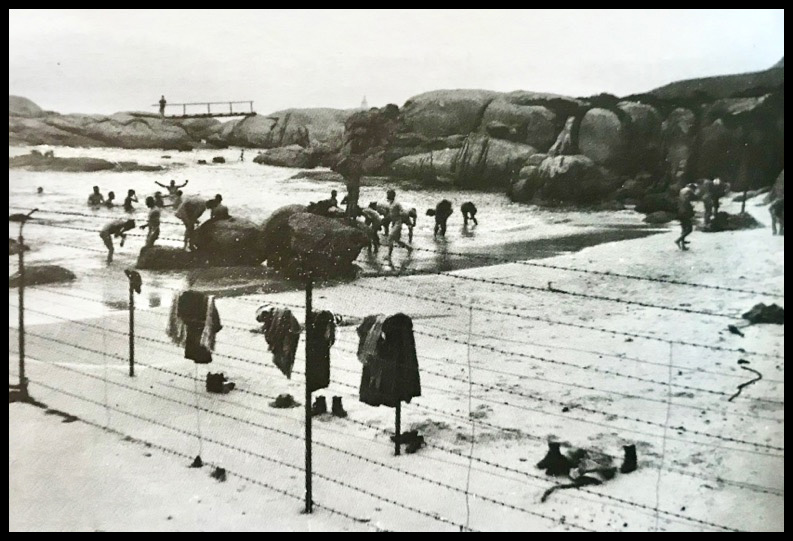
4]. Republican POWs swim in the nude at WindMill Beach below Bellevue POW Camp. I have lifted this from the AngloBoerWar.com website whose work I acknowledge.
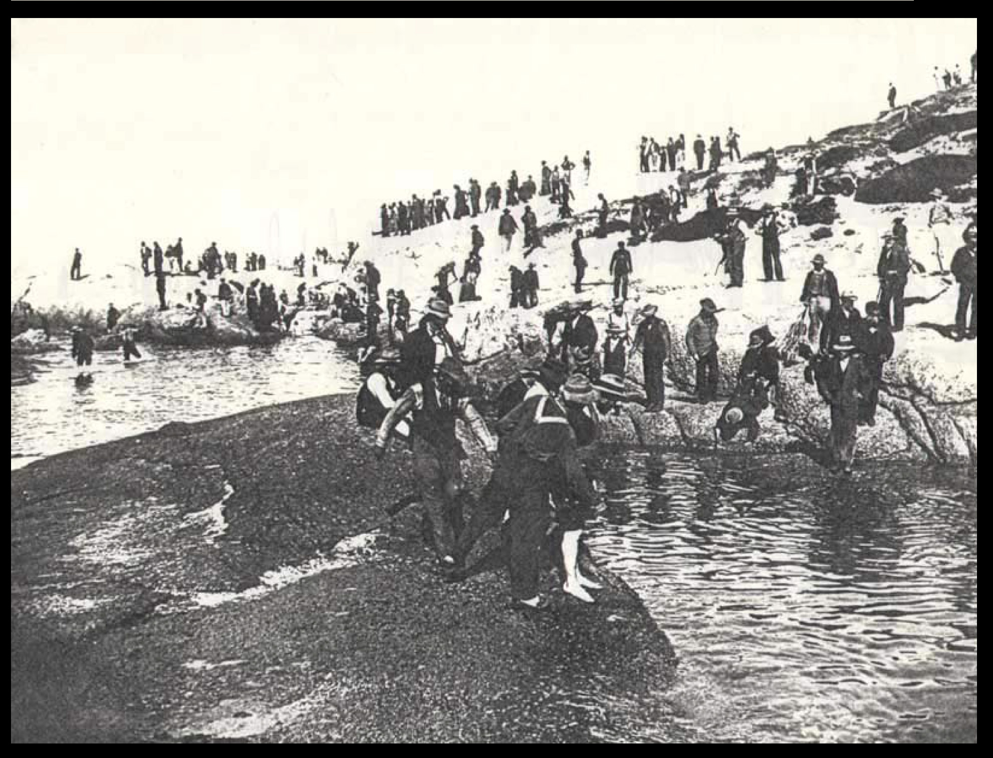
5]. Republican POWs on the prominitory and on Windmill Beach. I have seen this image captioned 'Boer Prisoners-of-War --- Seaforth Area, Windmill Beach'. This is a fudge by someone unable to decide where this is. It is not Seaforth.
Next, I will post some contemporary photos of the area around Bellevue.
First, a photo of me, standing outside the Aloes with my catch, about 1961. I am not proud of myself today for ending this poor creature's life. That said, a much larger shark took the species' primordial revenge by scaring me witless a few years later when I was spearfishing at Miller's Point with my pal Keith Ralph who has now cage-dived with great whites at Gansbaai. Shark-filled water are not for me, thank you!
The real reason for showing this is that my back is to Boulders Beach, Seaforth and Simon's Bay, neither of which you can see from where I am standing in the elevated car park of The Aloes / Boulders Beach looking south towards Bellevue and Cape Point. I show this because the 'lonely guard' photo claims to show Bellevue Camp with Simon's Bay and ships in the background. That cannot be. It is an impossible view. That photo is of South Camp which over-looked Simon's Bay.
Images
1]. Me at Boulders looking towards Bellevue, (which I cannot see), my back to Simon's Bay, (which you cannot see). My point is - there is no view of Bellevue POW Camp that will show Simon's Bay with ships unless taken from a very high vantage point.
2]. An enlarged high resolution of Bellevue POW Camp - with prisoners, guards, walls and barbed wire.
3]. A view of Bellevue from the coast looking up towards the main rood to Cape Point. The camp appears to be on quite a slope. I have lifted this from the AngloBoerWar.com website whose work I acknowledge.
4]. Republican POWs swim in the nude at WindMill Beach below Bellevue POW Camp. I have lifted this from the AngloBoerWar.com website whose work I acknowledge.
5]. Republican POWs on the prominitory and on Windmill Beach. I have seen this image captioned 'Boer Prisoners-of-War --- Seaforth Area, Windmill Beach'. This is a fudge by someone unable to decide where this is. It is not Seaforth.
Next, I will post some contemporary photos of the area around Bellevue.
Uploaded files:
Quote from Steve on November 20, 2023, 12:43 pmHere are a few images of the area where Bellevue POW Camp stood.
The camp stood on the golf course close to the shore with promonitory between it and the sea. Much has changed in the 120 years since the camp opened. It was used as late as early 1903 when POWs returning from overseas arrived by ship in Simonstown were processed in and repatriated through Bellevue Camp before being sent home. The camp, such as it still was, was used in 1915 as a training camp for the mixed-race Cape Corps who served the unappreciative Union of South Africa with distinction in GEA and the Middle East during WW1.
The slow creep of suburbia has changed the area forever. The needs of golfers saw all the boulders lying in the foreground of my Bellevue Camp photo dynamited and removed in the 1960s, I believe. A footpath, curiously called Burgher's Walk, (a reference to the Republican POWs?), snakes along the coast. The embankment of sand and grass built around the camp can still be seen in parts close to Bellevue Road which runs down from the Main Road to the sea. This presumably would have been the northern end of the camp.
In trying to identify the exact position of the camp I thought that the rocks out to sea would prove useful. It appears that the photo was taken during a Spring Low Tide which has made all the rocks appear more prominent than is usually the case. Nevertheless, they provide a useful pointer. I am grateful to Alan MacGregor who lives in the area for taking many of the photos shown here.
Images:
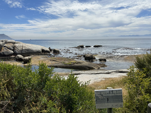
1]. Coastal access to Windmill Beach from Links Crecent along Burghers Walk.
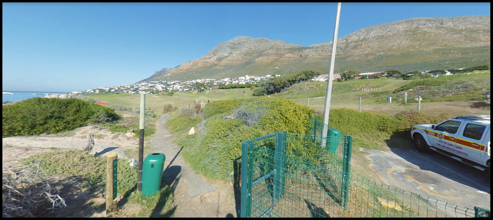
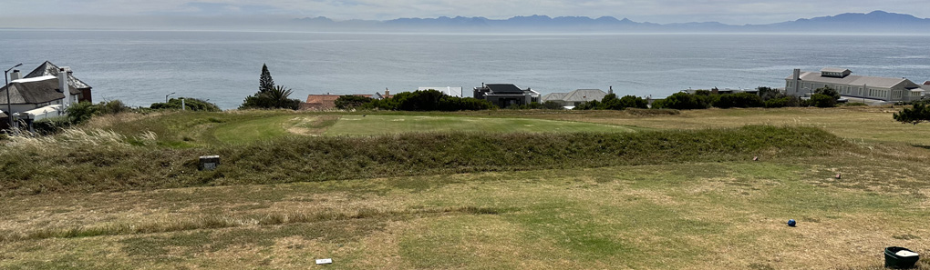
2]. Windmill Beach and the Golf Course, sans boulders but added sandpits.
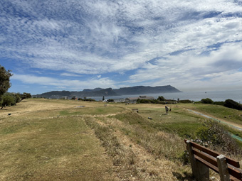
3]. The golf course from higher up, closer to the Main Road.
4]. Possible remanants of the wall with Belvedere Road on left leading to Links Crescent. Unfortunately, the houses above the shoreline make it impossible to see the Three Rocks which are seen in my photo more-or-less opposite the centre of the camp. They lie, according to Alan, approximately opposite the big building right.
Here are a few images of the area where Bellevue POW Camp stood.
The camp stood on the golf course close to the shore with promonitory between it and the sea. Much has changed in the 120 years since the camp opened. It was used as late as early 1903 when POWs returning from overseas arrived by ship in Simonstown were processed in and repatriated through Bellevue Camp before being sent home. The camp, such as it still was, was used in 1915 as a training camp for the mixed-race Cape Corps who served the unappreciative Union of South Africa with distinction in GEA and the Middle East during WW1.
The slow creep of suburbia has changed the area forever. The needs of golfers saw all the boulders lying in the foreground of my Bellevue Camp photo dynamited and removed in the 1960s, I believe. A footpath, curiously called Burgher's Walk, (a reference to the Republican POWs?), snakes along the coast. The embankment of sand and grass built around the camp can still be seen in parts close to Bellevue Road which runs down from the Main Road to the sea. This presumably would have been the northern end of the camp.
In trying to identify the exact position of the camp I thought that the rocks out to sea would prove useful. It appears that the photo was taken during a Spring Low Tide which has made all the rocks appear more prominent than is usually the case. Nevertheless, they provide a useful pointer. I am grateful to Alan MacGregor who lives in the area for taking many of the photos shown here.
Images:
1]. Coastal access to Windmill Beach from Links Crecent along Burghers Walk.
2]. Windmill Beach and the Golf Course, sans boulders but added sandpits.
3]. The golf course from higher up, closer to the Main Road.
4]. Possible remanants of the wall with Belvedere Road on left leading to Links Crescent. Unfortunately, the houses above the shoreline make it impossible to see the Three Rocks which are seen in my photo more-or-less opposite the centre of the camp. They lie, according to Alan, approximately opposite the big building right.
Uploaded files: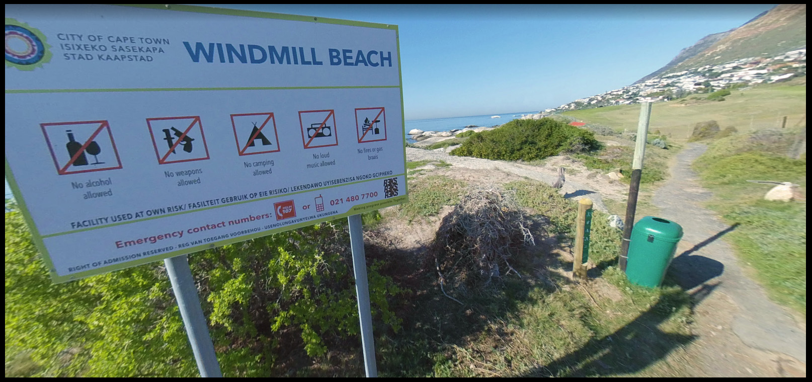
Quote from Steve on November 20, 2023, 5:00 pmHere are the last two images sent to me by Alan MacGregor.
They show the Three Rocks photographed from in front of the houses and the South Rocks after walking down Burgher Walk.
It would appear that Bellevue POW Camp began at or just after Bellevue Road and probably covered at least part of the area now occupied by houses and quite probably a bit more.
I hope to visit this area in 2024 and will revise this post if need be after that. In the meantime, as I have not visited the area myself, you are encouraged to post your comments about my observations here.
Images
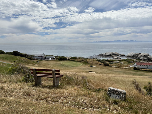
1]. According to Alan MacGregor, the Three Rocks lie just offshore from the large building shown last in the previous post.
2]. The South Rocks are roughly the southern end of Bellevue Camp.
Here are the last two images sent to me by Alan MacGregor.
They show the Three Rocks photographed from in front of the houses and the South Rocks after walking down Burgher Walk.
It would appear that Bellevue POW Camp began at or just after Bellevue Road and probably covered at least part of the area now occupied by houses and quite probably a bit more.
I hope to visit this area in 2024 and will revise this post if need be after that. In the meantime, as I have not visited the area myself, you are encouraged to post your comments about my observations here.
Images
1]. According to Alan MacGregor, the Three Rocks lie just offshore from the large building shown last in the previous post.
2]. The South Rocks are roughly the southern end of Bellevue Camp.
Uploaded files:
Quote from Steve on November 22, 2023, 5:55 pmSome further thoughts on '"The lonely guard at the entrance to Belle Vue Camp".
First, this is a very poor quality photo. Its absence of detail limits our ability to make confident judgements. Nevertheless, we must thank the Simons Town Museum for making it available to us. We would be worse off for not having it available to us.
1]. Judging by the number of ships in Simon's Bay, this photo was probably taken during the SAW (South African War, 1899 - 1902). However, other photos of Simon's Bay early in the SAW, especially during the first year of the war show it to be much busier.
2]. The 'lonely guard' (not my phrase) stands with his back to the Camp. He is facing away from the direction in which danger might come in the form of escaping POWs. If he was guarding the Camp to prevent people from escaping, he would be facing the camp, not looking the other way. (Due to the absence of detail, we cannot see if there are two guards standing back-to-back.)
3]. There appears to be no perimeter fencing or barrier around the camp, nor anyone inside it. Compare this to Jenks photo of Bellevue Camp which teems with men. This camp appears unoccupied. I suggest the guard is on duty to prevent thieves getting in, not out. The postcard I showed suggests that tents were erected here from time to time before the war for whatever reason. Perhaps this is one of those times? There would certainly have been a need for extra accomodation for naval and army personnel in Simonstown at the start of the SAW. This could even be South Camp after it closed when its prisoner's went overseas or to Bellevue. Or even later in the war. Does it look like a camp full of desperate Republicans who represent a dire threat to the Cape Colony and the Empire?
4]. Based on the fact that you cannot see Simon's Bay from Bellevue Camp or Boulders, this direct, clear close-up view of ships in Simon's Bay suggests that this photo can only be the Naval Sports Ground seen from the southerly high ground lying between the camp and the road. The Martello Tower is out of sight to the left.
Oh for a higher-res image!
Some further thoughts on '"The lonely guard at the entrance to Belle Vue Camp".
First, this is a very poor quality photo. Its absence of detail limits our ability to make confident judgements. Nevertheless, we must thank the Simons Town Museum for making it available to us. We would be worse off for not having it available to us.
1]. Judging by the number of ships in Simon's Bay, this photo was probably taken during the SAW (South African War, 1899 - 1902). However, other photos of Simon's Bay early in the SAW, especially during the first year of the war show it to be much busier.
2]. The 'lonely guard' (not my phrase) stands with his back to the Camp. He is facing away from the direction in which danger might come in the form of escaping POWs. If he was guarding the Camp to prevent people from escaping, he would be facing the camp, not looking the other way. (Due to the absence of detail, we cannot see if there are two guards standing back-to-back.)
3]. There appears to be no perimeter fencing or barrier around the camp, nor anyone inside it. Compare this to Jenks photo of Bellevue Camp which teems with men. This camp appears unoccupied. I suggest the guard is on duty to prevent thieves getting in, not out. The postcard I showed suggests that tents were erected here from time to time before the war for whatever reason. Perhaps this is one of those times? There would certainly have been a need for extra accomodation for naval and army personnel in Simonstown at the start of the SAW. This could even be South Camp after it closed when its prisoner's went overseas or to Bellevue. Or even later in the war. Does it look like a camp full of desperate Republicans who represent a dire threat to the Cape Colony and the Empire?
4]. Based on the fact that you cannot see Simon's Bay from Bellevue Camp or Boulders, this direct, clear close-up view of ships in Simon's Bay suggests that this photo can only be the Naval Sports Ground seen from the southerly high ground lying between the camp and the road. The Martello Tower is out of sight to the left.
Oh for a higher-res image!
Uploaded files: