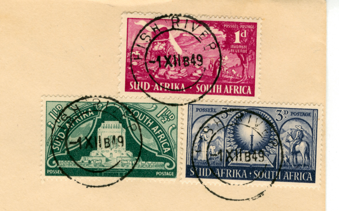
New 'FISH RIVER' Datestamp
Quote from Steve on September 24, 2022, 12:37 pmAmong other things, I am currently writing up a display on the wreck of the Grosvenor, East Indiaman, Captain Coxon, wrecked on the coast of Pondoland on 4th August 1782. During the writing up I came across the attached 'FISH RIVER' datestamp on cover. It looks ordinary enough, the sort of thing found on hundreds of First Day covers. As a result, I had ignored it for years. A few days ago I came across it again and decided to look it up in Putzel's 'Postmarks'. It wasn't there and nor was it in Alex Visser's Addendum.
Feeling rather foolish and thinking I must have missed something - it couldn't possibly be a new and undiscovered datestamp from the 1940s - I sent it off to Alex Visser in full expectation that I would end up with egg on my face. I pointed out to him that I thought the stamps and postmarks were a wonderful confluence in the tale of the Eastern Cape. For those who know nothing of South African history, the relevant facts here are these.
Following their arrival at the Cape in 1652, Europeans farmers (Dutch. ‘Boers’) had progressively moved eastwards along the line of the great coastal escarpment occupying what were once Khoi (Hottentot) lands. By the 1770s the settlers had reached the Zuurveld, an area of the Eastern Cape occupied each season by Xhosa cattle herdsmen who crossed over from the far bank of of the Fish River. In 1778, it seemed logical to the Dutch Governor of the Cape that the Fish River be declared the eastern boundary of the Colony. However, the Xhosa continued to cross the river and conflict over grazing land broke out between them and the Boer trekkers in 1780. This was the start of the Nine Frontier Wars which would take 100 years to conclude. After the British failed to adequately protect the Boer's from Xhosa raids (and vice versa, it must be said), the Boers decided on a Great Trek into the interior in search of farmland.
The stamps on piece below were issued by the new Nationalist government on 1st December 1949 to celebrate the inauguration of the Voortrekker Monument as a cornerstone of the Afrikaans people who then stood triumphantly in the center of the myth of White South Africa. These propaganda stamps have been cancelled with a First Day postmark from the disputed Fish River. For me these various threads are woven into a wonderful historic confluence. Many similar 'Voortrekker' covers, especially the two from 1938, are cancelled with historic place name postmarks relevant to the Voortrekker commemorations. This was not uncommon but few come from areas where Black people mounted such a fierce and stubborn resistance as along the Fish Rivers,ultimately forcing the Boer migration to take the easier option of going around the Xhosa while heading for the interior. The new government of 1948 were ardent Nationalists and segregationists who used historic events like the Great Trek to further their vision of White South Africa. Their policy of Apartheid attempted to glue the myth into shape while ordering Black South Africans to the political margins.
Today I received Alex's reply. He says of my cover and its postmarks that it is “A most interesting item, and brand new. Following is my entry in the Addendum. Thanks for sharing with me. ‘26 mm circle. Full date with time code letter (1949). Evidently used after return to Post Office control in 1947 and before renaming to VISRIVIER in 1953’.
Alex's contribution reveals something of 'die stryd' (the struggle) between Boer and Brit. This conflict can be seen in the new Afrikaner Nationalist government changing the unilingual English ‘FISH RIVER’ to the unilingual Afrikaans ‘VISRIVIER’ in 1953. Why? Tit for tat! Afrikaners had good reasons to want to get even with the 'verdomde rooinekke' (Afr. damned rednecks - English). After the South African War English was briefly the only official language in the conquered republics! However, by the early 1920s all official communications had to be in both languages, English and the new Afrikaans. This included datestamps where both groups used a different form of a town name, like 'EAST LONDON' and 'OOS LONDEN'. The only reason for changing 'FISH RIVER' to 'VISRIVIER' would have been if the English did not use the term 'FISH RIVER' at all. This was simply NOT the case. This instance appears to be anti-English Nationalist spite. The irony of the matter is that it was Xhosa that then was and still is the predominant language spoken in this area, hence the many post-Apartheid democratic era changes in Eastern Cape place names from English and or Afrikaans to Xhosa ones. Nevertheless, 'FISH RIVER' and 'VISRIVIER' continue to be used today.
Among other things, I am currently writing up a display on the wreck of the Grosvenor, East Indiaman, Captain Coxon, wrecked on the coast of Pondoland on 4th August 1782. During the writing up I came across the attached 'FISH RIVER' datestamp on cover. It looks ordinary enough, the sort of thing found on hundreds of First Day covers. As a result, I had ignored it for years. A few days ago I came across it again and decided to look it up in Putzel's 'Postmarks'. It wasn't there and nor was it in Alex Visser's Addendum.
Feeling rather foolish and thinking I must have missed something - it couldn't possibly be a new and undiscovered datestamp from the 1940s - I sent it off to Alex Visser in full expectation that I would end up with egg on my face. I pointed out to him that I thought the stamps and postmarks were a wonderful confluence in the tale of the Eastern Cape. For those who know nothing of South African history, the relevant facts here are these.
Following their arrival at the Cape in 1652, Europeans farmers (Dutch. ‘Boers’) had progressively moved eastwards along the line of the great coastal escarpment occupying what were once Khoi (Hottentot) lands. By the 1770s the settlers had reached the Zuurveld, an area of the Eastern Cape occupied each season by Xhosa cattle herdsmen who crossed over from the far bank of of the Fish River. In 1778, it seemed logical to the Dutch Governor of the Cape that the Fish River be declared the eastern boundary of the Colony. However, the Xhosa continued to cross the river and conflict over grazing land broke out between them and the Boer trekkers in 1780. This was the start of the Nine Frontier Wars which would take 100 years to conclude. After the British failed to adequately protect the Boer's from Xhosa raids (and vice versa, it must be said), the Boers decided on a Great Trek into the interior in search of farmland.
The stamps on piece below were issued by the new Nationalist government on 1st December 1949 to celebrate the inauguration of the Voortrekker Monument as a cornerstone of the Afrikaans people who then stood triumphantly in the center of the myth of White South Africa. These propaganda stamps have been cancelled with a First Day postmark from the disputed Fish River. For me these various threads are woven into a wonderful historic confluence. Many similar 'Voortrekker' covers, especially the two from 1938, are cancelled with historic place name postmarks relevant to the Voortrekker commemorations. This was not uncommon but few come from areas where Black people mounted such a fierce and stubborn resistance as along the Fish Rivers,ultimately forcing the Boer migration to take the easier option of going around the Xhosa while heading for the interior. The new government of 1948 were ardent Nationalists and segregationists who used historic events like the Great Trek to further their vision of White South Africa. Their policy of Apartheid attempted to glue the myth into shape while ordering Black South Africans to the political margins.
Today I received Alex's reply. He says of my cover and its postmarks that it is “A most interesting item, and brand new. Following is my entry in the Addendum. Thanks for sharing with me. ‘26 mm circle. Full date with time code letter (1949). Evidently used after return to Post Office control in 1947 and before renaming to VISRIVIER in 1953’.
Alex's contribution reveals something of 'die stryd' (the struggle) between Boer and Brit. This conflict can be seen in the new Afrikaner Nationalist government changing the unilingual English ‘FISH RIVER’ to the unilingual Afrikaans ‘VISRIVIER’ in 1953. Why? Tit for tat! Afrikaners had good reasons to want to get even with the 'verdomde rooinekke' (Afr. damned rednecks - English). After the South African War English was briefly the only official language in the conquered republics! However, by the early 1920s all official communications had to be in both languages, English and the new Afrikaans. This included datestamps where both groups used a different form of a town name, like 'EAST LONDON' and 'OOS LONDEN'. The only reason for changing 'FISH RIVER' to 'VISRIVIER' would have been if the English did not use the term 'FISH RIVER' at all. This was simply NOT the case. This instance appears to be anti-English Nationalist spite. The irony of the matter is that it was Xhosa that then was and still is the predominant language spoken in this area, hence the many post-Apartheid democratic era changes in Eastern Cape place names from English and or Afrikaans to Xhosa ones. Nevertheless, 'FISH RIVER' and 'VISRIVIER' continue to be used today.
Uploaded files: