Once again De Langesdrift
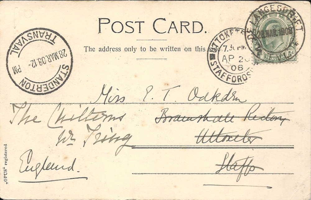
Quote from Albertlr on January 6, 2021, 10:22 amI want to show you, another Post Card those I found on E-Bay with De Langesdrift cancellation. Sent 28 MAR. 1908 via Standerton same day, to Engeland. Arrived AP. 20 1908. The Post-Card shows de Fouriesburg. Postmarked with 1/2d Transvaal King Eduard VII.
I want to show you, another Post Card those I found on E-Bay with De Langesdrift cancellation. Sent 28 MAR. 1908 via Standerton same day, to Engeland. Arrived AP. 20 1908. The Post-Card shows de Fouriesburg. Postmarked with 1/2d Transvaal King Eduard VII.
Uploaded files:
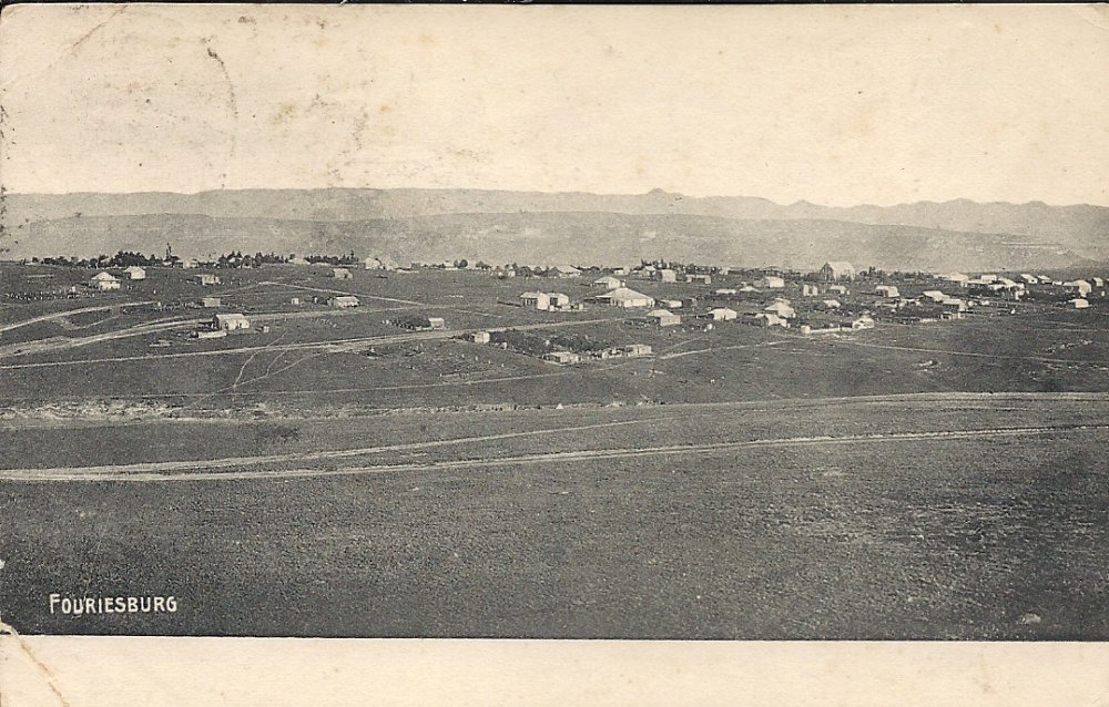
Quote from Steve on January 6, 2021, 11:05 amAnd a bit about Fouriesburg
Nice postcard, nice postmarks. Albert, please note that I have moved your post from 'EDITORIAL' to 'Stamps, Covers, Postmarks, Postcards & Ephemera'. In future, please make your very welcome posts in this forum. Thanks.
I realise that the postmarks are of more interest to viewers than the postcard BUT .... it has a story to tell as well.
It shows Fouriesburg over 115 years ago. It looks basic and primitive, more a camp than a town. When this photo was taken the South African War had presumably just ended. Wikipedia, (which is not always correct), says "During the late nineteenth century, this land was donated to the Orange Free State by a local farmer of Huguenot descent, Christoffel Fourie. It was the site of several engagements during the Boer War, and by 1902 the original settlement had been almost completely destroyed." According to Putzel, "the town was established in 1892 on the farm Grootfontein belong to Christoffel 'Rooi' (Red) Fourie and named after him". It is likely that the view shown in the postcard was taken after the South African War and shows the town recovering from the devastation caused by the British. Fouriesburg was just one of several small OFS towns that were razed to the ground after the British Army realised that it was more trouble than it was worth attempting to hold them during the guerilla war phase of the conflict.
And a bit about Fouriesburg
Nice postcard, nice postmarks. Albert, please note that I have moved your post from 'EDITORIAL' to 'Stamps, Covers, Postmarks, Postcards & Ephemera'. In future, please make your very welcome posts in this forum. Thanks.
I realise that the postmarks are of more interest to viewers than the postcard BUT .... it has a story to tell as well.
It shows Fouriesburg over 115 years ago. It looks basic and primitive, more a camp than a town. When this photo was taken the South African War had presumably just ended. Wikipedia, (which is not always correct), says "During the late nineteenth century, this land was donated to the Orange Free State by a local farmer of Huguenot descent, Christoffel Fourie. It was the site of several engagements during the Boer War, and by 1902 the original settlement had been almost completely destroyed." According to Putzel, "the town was established in 1892 on the farm Grootfontein belong to Christoffel 'Rooi' (Red) Fourie and named after him". It is likely that the view shown in the postcard was taken after the South African War and shows the town recovering from the devastation caused by the British. Fouriesburg was just one of several small OFS towns that were razed to the ground after the British Army realised that it was more trouble than it was worth attempting to hold them during the guerilla war phase of the conflict.
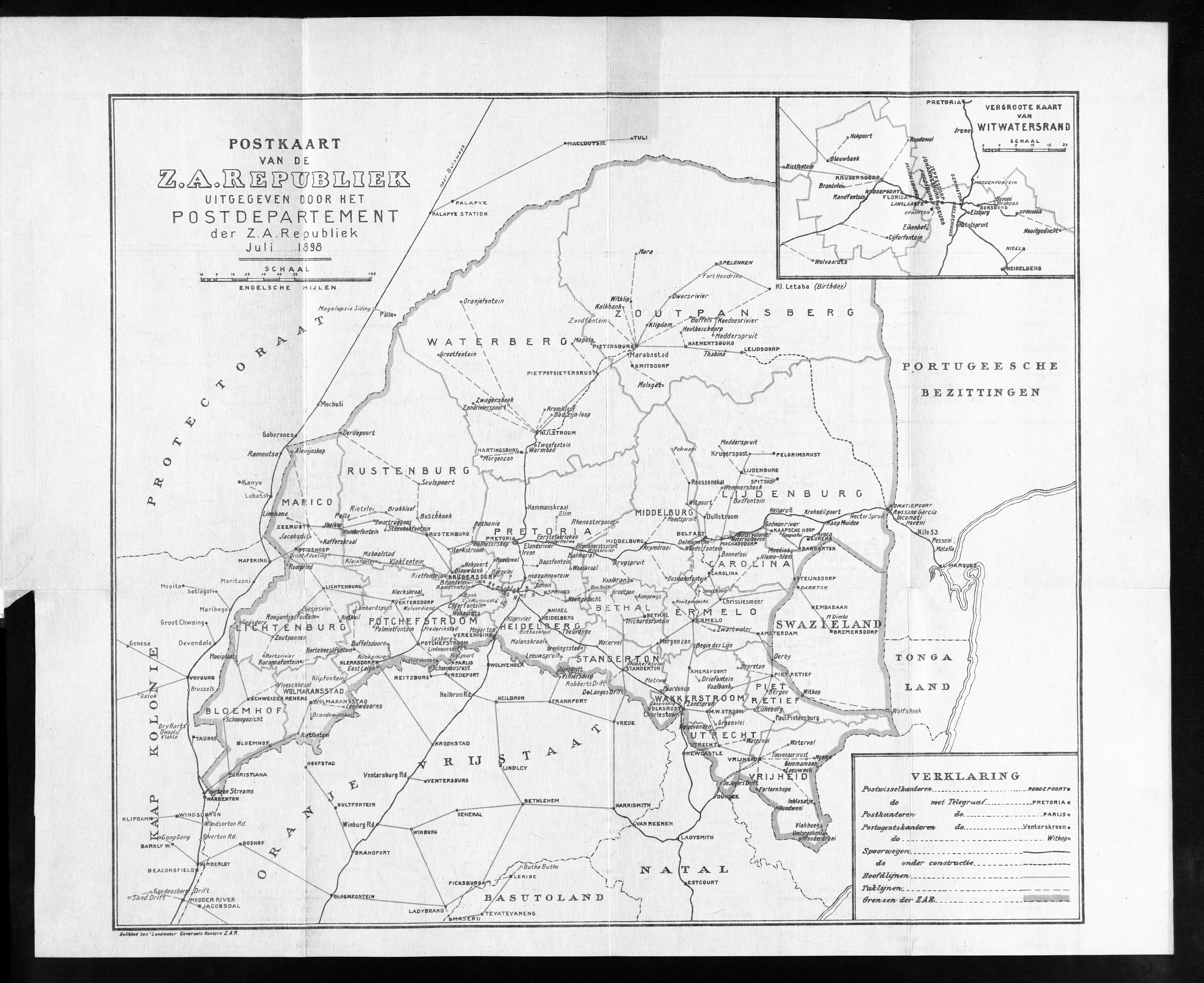
Quote from Albertlr on January 27, 2021, 3:33 pmWho can tell me where is De Langesdrift on the map. Does anyone have a map of the area?
Who can tell me where is De Langesdrift on the map. Does anyone have a map of the area?
Uploaded files: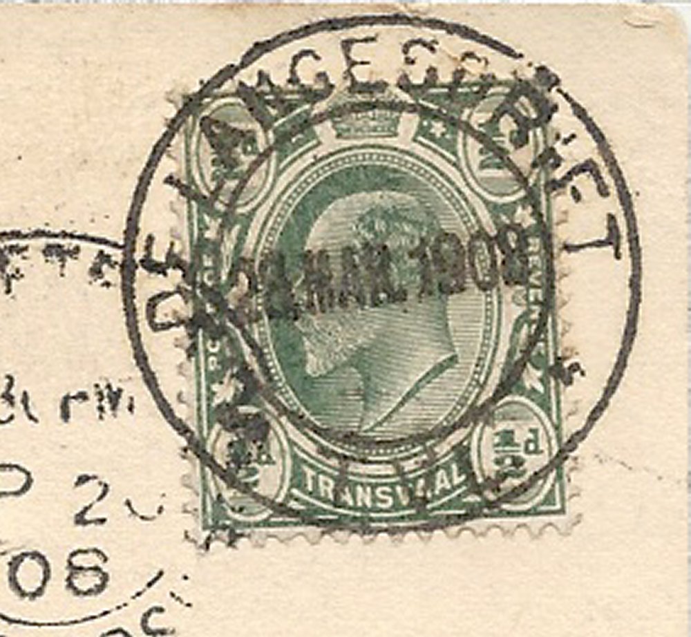
Quote from Bas PAYNE on January 27, 2021, 3:51 pmDear Albert,
De Langesdrift is about 20 km S of Standerton, very close to the OFS border. It's shown on the map from the 1898 Postgids - scan attached in the hope that you (and others) may find it useful. It's also shown on the map on the endpapers of Mathews' Transvaal Philately.
Dear Albert,
De Langesdrift is about 20 km S of Standerton, very close to the OFS border. It's shown on the map from the 1898 Postgids - scan attached in the hope that you (and others) may find it useful. It's also shown on the map on the endpapers of Mathews' Transvaal Philately.
Uploaded files: