
Witpoort
Quote from Albertlr on January 9, 2021, 6:25 pmI have this card: Orange River Colony postal stationery card sent from Bloemfontein 9.SEP 09 O.R.C.1 via Belfast 11 SEP 09 to Witpoort 12 SEP 09.
When I view the places on google maps then Witpoort is located north of Johannesburg. Then it seems unlikely to me that this card was sent via Belfast? But maybe there is another place called Witpoort? Who will clarify me?
I have this card: Orange River Colony postal stationery card sent from Bloemfontein 9.SEP 09 O.R.C.1 via Belfast 11 SEP 09 to Witpoort 12 SEP 09.
When I view the places on google maps then Witpoort is located north of Johannesburg. Then it seems unlikely to me that this card was sent via Belfast? But maybe there is another place called Witpoort? Who will clarify me?
Uploaded files: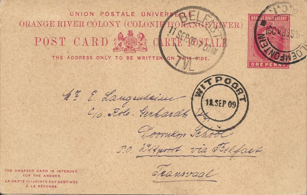
Quote from Bas PAYNE on January 9, 2021, 7:29 pmAnother great card ....
Putzel lists three PAs called Witpoort in the ZAR and Transvaal. The only one that is listed as having been open in 1909 is Witpoort whose head office was Middelburg - it was open from 1888-1959. It's about 40 km NE of Middelburg, and about the same distance NNW of Belfast. It would have been a little further to route the card via Belfast, but presumably there was a reason.
Another great card ....
Putzel lists three PAs called Witpoort in the ZAR and Transvaal. The only one that is listed as having been open in 1909 is Witpoort whose head office was Middelburg - it was open from 1888-1959. It's about 40 km NE of Middelburg, and about the same distance NNW of Belfast. It would have been a little further to route the card via Belfast, but presumably there was a reason.
Quote from Steve on January 10, 2021, 12:18 pmYes, very nice, clean with neat postmark strikes. Almost Swiss postal quality! Keep them coming, Albert!
Yes, very nice, clean with neat postmark strikes. Almost Swiss postal quality! Keep them coming, Albert!
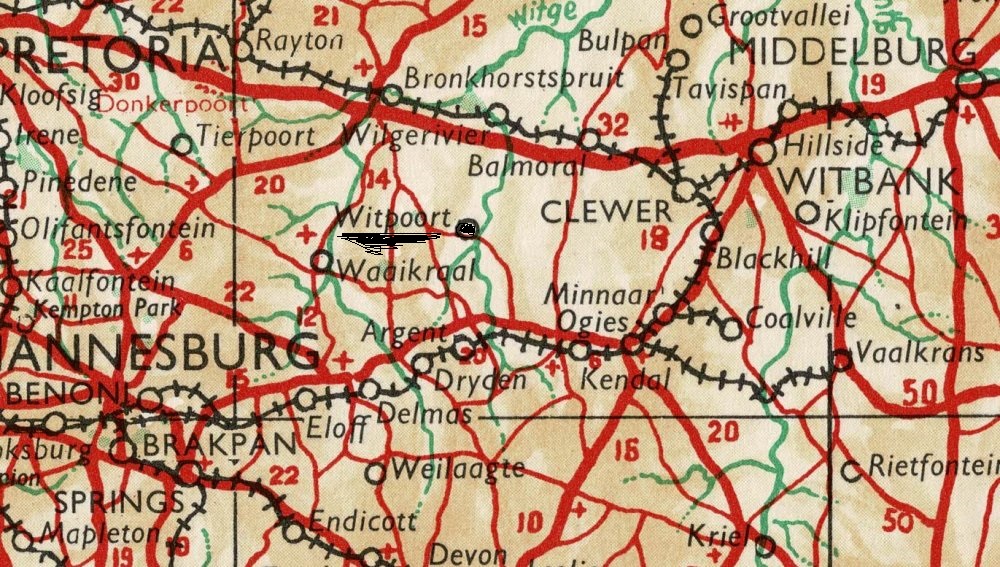
Quote from Bas PAYNE on January 10, 2021, 5:37 pmThe Witpoort I think your card was sent to is marked with a red square on this map, which is taken from the 1898 Postgids, and is NE of Middelburg. As the map indicates, at that date it was served by a postal route from Belfast, even though it was in Middelburg district. It is also marked in about the same position on the map in the back of Mathews' Transvaal Philately, which shows post offices and agencies in 1910.
The Witpoort marked on your map is roughly in the position I've marked with a blue star, WSW of Middelburg. It has probably never had a postal agency. The other two Witpoorts listed by Putzel are elsewhere - one in the Wolmaransstad district which existed briefly in 1899, and the other near Heidelberg which was renamed Greylingstad in 1891.
I hope this helps - it's sometimes hard to sort things out when several PAs have the same name, especially as they were often shortlived and may have had their names changed ....
The Witpoort I think your card was sent to is marked with a red square on this map, which is taken from the 1898 Postgids, and is NE of Middelburg. As the map indicates, at that date it was served by a postal route from Belfast, even though it was in Middelburg district. It is also marked in about the same position on the map in the back of Mathews' Transvaal Philately, which shows post offices and agencies in 1910.
The Witpoort marked on your map is roughly in the position I've marked with a blue star, WSW of Middelburg. It has probably never had a postal agency. The other two Witpoorts listed by Putzel are elsewhere - one in the Wolmaransstad district which existed briefly in 1899, and the other near Heidelberg which was renamed Greylingstad in 1891.
I hope this helps - it's sometimes hard to sort things out when several PAs have the same name, especially as they were often shortlived and may have had their names changed ....
Uploaded files:
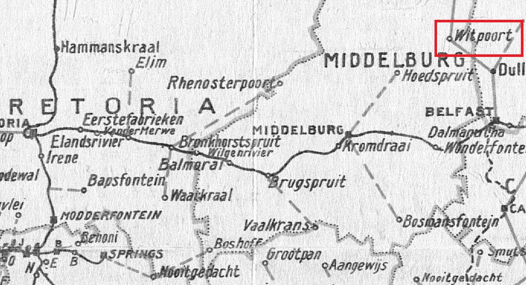
Quote from Bas PAYNE on January 10, 2021, 5:40 pmSorry - I uploaded the wrong map, with no blue star; here's the one I intended to upload
Sorry - I uploaded the wrong map, with no blue star; here's the one I intended to upload
Uploaded files: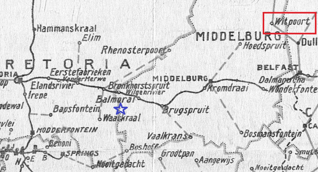
Quote from Jamie Smith on January 10, 2021, 5:51 pmI go for the one north of Belfast. In the 1990's I birded both areas for the atlas project and both areas were little more than farms. Often I would see a signpost for a place and when I got there it was a farm not a village - this could account for there being two places in the area with the same name
.
I go for the one north of Belfast. In the 1990's I birded both areas for the atlas project and both areas were little more than farms. Often I would see a signpost for a place and when I got there it was a farm not a village - this could account for there being two places in the area with the same name
.